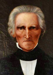
A goal this week has been to finish a couple of brief history-related pieces for a Lucas County-related web site currently under development. There's nothing new here, but I've recast, condensed and added a little to previous posts so it's my best effort, at the moment, to summarize our history. The rather severe looking gentleman at left is Iowa's first territorial governor, Robert Lucas, after whom we're named.
+++
Lucas County, with a population of approximately 8,600, is located midway between the Mississippi and Missouri rivers in the Iowa’s second tier of southern counties. Created in 1846 and organized in 1849, it is named for Robert Lucas, Iowa’s first territorial governor. A mix of scenic wooded hills, river and creek valleys and former prairie that now is productive farm land, the county’s economic base is agriculture, small industry and large-scale distribution. Thousands of acres of public parks, state forests and reserves make it a popular recreational destination.
+++
Lucas County was, until the fall of 1842, recognized by the U.S. government as territory of the confederated Sauk and Fox (Meskwaki) nations and therefore closed to land claims by non-native settlers.
Although native Americans (most notably the Ioway for whom Iowa is named) had lived and hunted here for millennia, as their artifacts testify, they had touched the land lightly. It remained virgin prairie astraddle a high curved ridge dividing the Mississippi and Missouri river drainages punctuated by creek and river valleys fringed by timber and marsh.
The Chariton River, which flows south to join the Missouri River between Kansas City and St. Louis, and White Breast Creek, which flows north to join the Des Moines River north of Knoxville, are its two principal streams. The most widely known land mark during the earliest days was Chariton Point, just south of what now is the county seat city of Chariton, where the river of that name reached its most northerly point.
Under terms of a treaty signed at the Sauk and Fox agency east of what now is Ottumwa on Oct. 11, 1842, the Sauk, led by principal chief Keokuk, and the Fox, led by Poweshiek, ceded all of their claims to land west of the Mississippi to the United States in return for various financial considerations and the promise of new land in "Indian Territory" west of the Missouri River.
Under terms of that treaty, the Sauk and Fox agreed to move prior to May 1, 1843, west of a line drawn north to south from the Neutral Ground in northern Iowa to the Missouri border through the red rocks on the White Breast fork of the Des Moines River. That Red Rock Line formed roughly what now is the Lucas-Monroe county line.
The Sauk and Fox were given three years of grace to occupy the land west of the Red Rock Line, including Lucas County's territory, but pledged to leave Iowa by the third anniversary of the treaty, Oct. 11, 1845.
Lucas County was created three months after the Sauk and Fox title expired by an act of the final Iowa territorial Legislature dated Jan. 13, 1846, and named for Robert Lucas, the first territorial governor. That act defined county boundaries, directed that the uncharted territory be surveyed and placed it under the jurisdiction of Monroe County, which already was administering as best it could a county-wide strip of territory that stretched all the way to the Missouri River.
+++
So far as anyone knows, there were no permanent settlers in Lucas County during that January, but history and geography soon would combine to turn the broadly curved ridge that bisects it into one of the nation's busiest highways.
During the spring of 1846, refugee members of the Church of Jesus Christ of Latter-day Saints, generally known as Mormons, began their flight west from Nauvoo, Illinois, across Iowa toward their eventual destination, the great Salt Lake Valley of Utah.
The first Saints, led by Brigham Young, crossed the iced-over Mississippi on Feb. 4, 1846. Upon arrival at Garden Grove in what now is Decatur County during late April, Young sent scouts back to direct those who followed to blaze a trail that followed the broad ridge that divides Lucas County. That trail crossed what now is the courthouse square in Chariton.
Thousands followed that trail, including the family party of Elder Freeman Nickerson, his wife, Huldah, and others who arrived at Chariton Point during November of 1846, but could go no farther as harsh winter weather descended. They spent the winter at Chariton Point and so were among the county’s earliest semi-permanent Euro-American residents. So far as is known, John and Hannah Ballard and their children, who had settled in English Township during August of 1846, were the only others living in the county at the time and they are considered to be the first permanent settlers.
A supplemental act ordering the organization of Lucas County and dated 14 January 1849 was passed by the second General Assembly of the state of Iowa. That act set July 4, 1849, as the date the county would gain its independence from Monroe and appointed James Roland, a resident of William McDermott’s "Ireland" neighborhood in Cedar Township, as organizing sheriff. His principal duty was to call an election on August 6, 1849, to select county officials and justices of the peace.
That election was duly held on Aug. 6 at the McDermott cabin with 25 men voting. Newly-elected county commissioners held their first meeting four days later, on Aug. 10, 1849, at the home of Buck Townsend, who by that time had purchased the Mormon claims and settled at Chariton Point. They were joined by three independent commissioners named by the Legislature to locate a county seat.
Those commissioners located and named the city of Chariton, just north of Chariton Point, an action affirmed by the new county commissioners on Aug. 11.
+++
Once established and organized, the county began to fill with new settlers and Chariton became something of a boom town in 1853 when the federal land office serving south and southwest Iowa was moved here from Fairfield.
Another boom era for the county came immediately after the Civil War when the first trains arrived in the county on tracks newly built by the Burlington & Missouri River Railroad (later Chicago, Burlington and Quincy; now Burlington Northern & Santa Fe). Two of the county’s smaller towns, Russell to the east in 1867 and Lucas to the west in 1868, were developed along these tracks. Branch lines were constructed north to Indianola and south, eventually to St. Joseph, Missouri, during the 1870s, leading to the establishment of Derby in 1872 and the now-ghost village of Oakley. Completion of the north-south Rock Island Railroad line through the county in 1913 added Williamson to the list of county towns and turned Chariton for a time into a major rail hub served by two depots.
Although Lucas County always has been primarily agricultural, known for livestock production, coal was discovered under the county during the late 1870s and developed into a major industry that helped to shape the county for more than 60 years. Lucas County was among Iowa’s largest coal producers during many of those years and its mines, the largest and most technologically advanced. Labor leader John L. Lewis was born during 1880 into a Welsh mining family near Lucas. Coal continued to be a major factor in the economy until World War II. The last mine, Big Ben, closed during 1978.
The Hy-Vee supermarket chain has been a major player in Lucas County’s economy since 1945, when the corporation’s headquarters were relocated to Chariton from Lamoni. Although corporate headquarters were moved to West Des Moines in 1995, Hy-Vee reached maturity in Lucas County and the Chariton Distribution Center remains the county’s largest employer.
Today, thousands of acres of public land offer limitless opportunities for outdoor recreation in Lucas County --- including Red Haw State Park, Stephens State Forest, the 13-mile Cinder Path recreational trail, Chariton River Greenbelt, Pin Oak Marsh and nature center and other smaller parks and natural areas.


No comments:
Post a Comment