I drove by Lloyd and Bessie May’s old home southwest of Russell a couple of weeks ago and just flat out had my heart broken: All that was left was a pile of ashes punctuated by two massive chimneys. What in the world happened? Don’t know and haven’t rounded up Betty Cross (nothing that happens in Russell escapes her) to ask.
This wonderful old house was built about 1881 by the Beals family, who sold it to Lloyd and Bessie long before my time. It sprawled all over the place. The principal glory was a circular walnut stairway that circled up to the second floor inside an entrance that projected from the south front of the main block. Behind were double parlors with smaller rooms beyond them. The dining room wing was east of that, and originally other rooms projected to the north of the dining room.
During the year I was shipped off to Vietnam, Lloyd and Bessie decided to move into Russell and their son-in-law and daughter, my cousins Dale and Mary Lou (May) Johnson, planned to move into the old house with their family. In the process of getting ready for the move, the Mays decided to burn excess papers in a stove attached to a chimney that wasn’t as sturdy as it had been 90 or so years earlier and set the place on fire. That took care of the north rooms and badly damaged the bedrooms above the dining room room wing.
Undeterred, Dale and Mary Lou removed the second floor of the dining room wing, cleaned the place up and moved in --- still plenty of room for a large family (old houses tended to be like that).
As the years passed, Dale died and finally Mary Lou moved a couple of years ago into a smaller and much more convenient house nearby (built by my great-grandfather, Daniel Myers Sr. for his son and daughter-in-law Nolan and Mary Stephens Myers, then moved up to the flats south of Russell when Uncle Nolan and Aunt Mary moved elsewhere).
The old May place fell into other hands, and when I drove by several months ago things were looking hopeful. The encroaching woods had been cleared and a new roof had been added. But now it’s all gone. I wonder if another chimney fire finished the work of the first.
If nothing else, that experience reminded me that I should set out to photograph some other buildings across southern Iowa that I admire --- but that are endangered. Who knows how long they’ll be around. So that’s what I did Monday.
Actually, I had promised myself I’d stay at home in Chariton and tend to business. But one thing led to another --- got the oil changed (finally) and it seemed a shame to waste fresh oil, the sun was shining (that didn’t last) and the colors of the fall foliage were at their best. And I needed eggs (I’m partial to those produced by the Burkholder hens at Mt. Sterling) and bread (none better than loaves produced by the Hillside Bakery near Milton). That all comes together, along with all sorts of other wonderful stuff, at the Mennonite-operated Dutchman’s Store at Cantril, just off Highway 2 between Bloomfield and Keosauqua. So I headed down U.S. 34 for lunch at Mom’s Café (chicken-friend steak and pepper gravy was the special of the day) in Albia and points beyond.
Floris is a little town tucked in the hills south of Ottumwa. I’ve admired the Floris Christian Church for years. I’m afraid it’s a gonner, but who knows? Separated from its congregation, it sits abandoned part way up the hill in the southwest part of town. The main block of the building is simple and probably wouldn’t grab a second glance, but the bell tower --- now that’s a wonder. According to the peeling sign above the front door, the church was built during 1895. It still looks fairly sturdy, but the roof is showing signs of wear --- and a bad roof is a sign of impending doom. So here it is, frozen in time at least temporarily.

Wednesday, October 26, 2005


This is the old Christian Church, built during 1895 in Floris. The building itself is very plain, but the bell tower --- especially its location along the side of the church rather than at one end or the other --- is spectacular, I think. It's the sort of building you'd like to wrap in a blanket and take home with you, but I suppose it's too large for that. If ever I've seen an endangered structure, this is it.

From Floris to Iowaville
From Floris, I twisted and curved east down out of the hills to the Des Moines River bottom, then headed southeast along the river's southwest bank to the Eldon crossing. The old river road to Iowaville follows the northeast bank of the river out of Eldon's southwest corner --- a pretty drive any day.
This broad, flat bottom is bloody ground. Here along the river was the principal village of the Ioway. And it was here, some say during 1819, that members of that tribe during early May were celebrating a successful winter buffalo hunt. The men reportedly were at a pony race on a course about two miles from the riverside village. Women, children and the old were in the village, preparing a feast.
Combined Sauk and Meskwaki forces under Pashepaho and Black Hawk approached the Ioway from hiding places in the tallgrass prairie and nearby woods and massacred them. There reportedly were more than a thousand dead here, and the Ioway were left a powerless remnant.
Keokuk then established a principal village of the Sauk and Meskwaki here on the bones of the Ioway, and white settlers established the settlement of Iowaville near the Sauk/Fox settlement as they filtered into the area during the 1830s.
After the disastrous Black Hawk war, the old chief returned to the Iowaville vicinity, settling with his family near the home of his friend, trader James Jordan. And it was here that he died Oct. 3, 1838.
Black Hawk was buried with considerable pomp upriver from Iowaville, somewhere in the neighborhood of the later lockkeeper's house, but soon thereafter the notorious James Turner desecrated the grave and removed the old chief’s head. It’s a certainty that the skull, recovered by state authorities and kept with permission of Black Hawk’s family in the collection of the Burlington Geological and Historical Society, burned when its headquarters went up in smoke during 1855.
Although a skeleton had been associated with the skull and also burned, tradition in Van Buren County holds that it was not Black Hawk’s. Instead, some say, the remainder of the old chief’s body was removed from its riverside burial place after the head was stolen and placed in the Iowaville Cemetery, visible where the bluffs rise from the bottom about a mile northeast of the old town. A grave there is honored as Black Hawk’s although there is some dispute about just what (if anything) it contains. I prefer to think Black Hawk is there.
Anyhow, beyond all of that, I’m interested in Iowaville because that’s where my Mormon pioneer, preacher and blacksmith Robert Rathbun came to rest during the 1840s as village smithy and proprietor of the Iowaville House --- a substantial (for that time) hotel serving the village. I’ll get around to Robert another day. He’s not going anywhere, buried as he is not far from Black Hawk in the old cemetery on the bluff.
This is about old buildings, and one sight to see along a curve of the river road between Eldon and the site (there’s not a trace of the old town now) of Iowaville is the stone lockkeeper’s house. This old building probably will survive --- it’s publicly owned if indifferently maintained --- but is certainly beginning to fray. When I stopped Monday, I noticed that shutters were missing from the upstairs gable-end windows and one corner of the roof had been damaged.
The old house was built prior to 1850 as part of an ambitious plan to improve the navigability of the Des Moines River from Keokuk to Fort Des Moines. That plan was abandoned not long after when it became clear railroads were the future of Iowa --- not riverboats. So the lock and dam the old house was intended to serve never were built. The old building, however, has survived flood, fire and just about everything else. And with any luck at all, it will be around for another 150 years or so. Or at least I hope so.
The word “Chief” is outlined in large concrete letters just southeast of the lockkeeper’s house. This is intended to indicate that Chief Black Hawk’s original grave was nearby.

This is the lockkeeper's house, dating from the 1840s, that was built to house the family of the man who would would have been hired to operate locks on the Des Moines River between Iowaville and Eldon had they been built. Signs of danger to this publicy-owned building are the damaged roof (left) and missing upstairs shutters. This photo was taken looking north from the river road across the broad bottom that was the site of the Sauk and Meskwaki massacre of the Iowas during the early 19th Century.


"Chief" in raised concrete letters just southeast of the lockkeeper's house refers to Chief Black Hawk, whose original grave was very near this site. Sand or gravel is being mined from beneath the bottom just northeast of the lockkeeper's house, which explains the unsightly pile in the background. Beyond are the bluffs that ring this broad river bottom.
Iowaville to Keosauqua to Cantril, then home
From the Iowaville site, I drove a mile north to Highway No. 16, turned downstream through Selma to Douds/Leando, then from Douds down along the north side of the Des Moines on gravel as far as I could go before being forced by abandoned roads and dead-ends to come back to Highway No. 1. A short trip from there down through Keosauqua, across the river, then four or so miles south of Keosauqua to the intersection of Highways 1 and 2, then west on No. 2 toward Cantril and the Dutchman’s Store.
Actually, there was a brief detour here. Mormon pioneer Nathaniel Ashby died very near here during 1846 not long after fleeing Nauvoo. An account written by his son many years after the fact states that the family was camped six miles west of Bonaparte when the death occurred and that he returned to Bonaparte to buy enough lumber to build a coffin for his father, who then was buried in a nearby grove next to the grave of another family's child who had been buried there shortly before. These graves, of course, are lost. But I drove around the sections northeast and northwest of the Highway 1/2 intersection, trying to go back 160 years in my head and figure out where in the vicinity of Indian Creek that camp might have been. Interesting country, but no luck.
A few miles west of Keosauqua on Highway No. 2, I turned south on a stub of the original Highway 2 paving (turned over to Van Buren County when the highway was straightened a good many years ago) to a wonderful old house --- now in grave danger.
I know nothing whatsoever about it, other than the fact it closely resembles the Isaiah Meek house at Bonaparte, generally dated 1848-1853. The curved widows are identical as are the roofline and the general layout. Although the Meek House appears to be somewhat larger, they are astonishingly alike and I’d be willing to bet were designed and constructed by the same hands.
Obviously, the house is derelict. On a positive note, the superb brickwork above a solid limestone basement is as sound as the day both basement and walls were put into place. And the roof is solid. Unfortunately, extensive vandalism has taken place. I glanced inside the front door (missing), but went no farther. The stair rail has been stolen. Many of the windows have been broken. It’s a a mess, and I fear for its future. But here it is as it stands during late October in this year of grace 2005.
The old pavement continues on for a ways before rejoining No. 2, but is in awful, bone-jarring condition. If you drive it, don't plan on traveling much faster than 35 mph. Around the corner and a ways onward to the west is another of Van Buren County's architectural treasures --- a spectacular turn-of-the-century brick and tile circular show barn. It's in good shape, although on private land --- a "for sale" sign out front --- and so vulnerable.
I didn't stop to photograph it (should have), but continued on to stock up at the Dutchman's, then high tail it for home before dusk brought every deer in southern Iowa out, daring motorists to hit them.

This wonderful old abandoned house southwest of Keosauqua is very similar to, although I'd say smaller than, the Isaiah Meek home on the river road at the west edge of Bonaparte. I'd be willing to bet they were designed and built by the same hands. Note the elaborate backeted cornice. The front porch, now missing, apparently went through two encarnations before being torn away. Originally, it was flat or very sligtly pitched, like the porch still in place on the Meek home. Later, the roof was reconfigured to a steeper pitch and at that time the sill of what had been a door opening onto the porch roof was raised above the roofline, a new sill installed and what appears to be part of the original door cut down to fill the opening. The semicircular light above the original door seems to be intact. Note, too, that modern windows have been placed in the original openings north of the front door. This is the home's east front.


This shot of the southeast upstairs window on the south front gives a closer view of the poor old home's superb brickwork. The window appears to be original, although only one pane of 12 remains in place. The brickwork just below the roof is notched to hold in place a cornice that has fallen to the ground.
Friday, September 23, 2005
That old empty feeling ...
Subtitle this, good neighbors are among the greatest gifts.
I've been thinking a lot this morning about Marie Linville, who died Tuesday at 73 in Chariton and who will be buried on Saturday in the Confidence Cemetery down in Wayne County.
My goodness, Marie and her husband, Richard, have been a part of my life since forever. I grew up south of Russell on the Wayne County line, and just a mile down the county line road east were Richard and Marie --- down the hill beyond Cousin Glenn and Pansy Chapman's place on the corner.
They had been married 50 years 7 August, I see --- and I remember that because suddenly later that fall the old house they had remodeled into a home was filled with light as we rattled past before dawn aboard the school bus headed into Russell.
And after that they were always there. My dad helped Richard and his son, Bruce, wrangle cattle time and time again. If we went on vacation, they did the chores and fed the dogs (my dad always called the Linvilles from wherever we happened to be to check on the dogs. God forbid they should miss us and not eat).
Time and time again, the Linvilles went up the road, then back, to-and-froming another of their farms. Time and time again, they stopped to visit.
Marie had a tough life. Rheumatoid arthritis left her twisted and in pain --- but undeterred. Pleasures were simple --- children and grandchildren, old-time country music, some travel, a piece of pie at Swan's Cafe in Promise City. A great and brave and gentle soul, hers.
I saw them last, I think, at lunch last fall down at Hardees in Chariton. Richard carried a little stool in the back of the battered old pickup so that Marie could step up as he helped her ever-so-carefully inside.
Grief is a funny thing. This is not the gut-wrenching accompaniment to the loss of a spouse, a child, a parent, someone intimately dear. It's an emptiness, a sense that there's another hole in life now. Blessed be ...
Here's Marie's obituary:
Marie Elizabeth Scheitel Linville, 73, died Tuesday September 20, 2005 at the Chariton Nursing & Rehab Center. Services will be Saturday, September 24, 2005 at 1 p.m. at the Pierschbacher Funeral Home in Chariton. Burial will be in the Confidence Cemetery. Family will receive friends from 6 to 8 p.m. Friday at the funeral home. Memorials may be made to Circle of Friends Home Care in Chariton.
Marie was born on October 20, 1931 in Potsdam, MN, and graduated from Rochester High School in 1949. After graduation, she was employed as a radio-iodine secretary at the Mayo Clinic from 1949 to 1955. She married Richard Ford Linville of Russell, IA on August 7, 1955 in Milroy, MN. Marie and Richard recently celebrated 50 years of marriage.
Those left to honor her memory include her husband, Richard of Russell; two sons, Bruce Linville of Ottumwa and Dennis Linville of Chariton; two daughters, Marceline (Dennis) Slack of Mediapolis, and Rhonda (Mark) White of Chariton; twelve grandchildren and five great-grandchildren; a sister, Eunice Hadel of Blaine, MN; a brother, Marvin Scheitel of Rochester, MN and several nieces and nephews.
Thursday, September 22, 2005

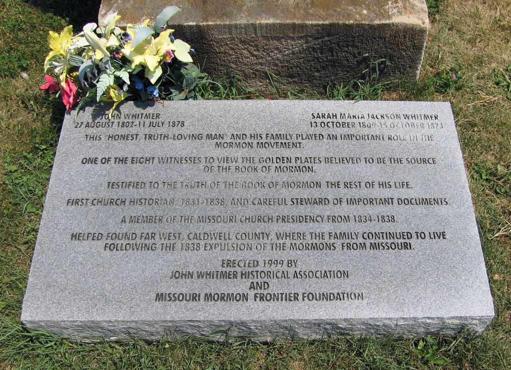
In case you're too tired to click and enlarge this photo of the granite tablet honoring John Whitmer, here's how the inscription reads, "John Whitmer, 27 August 1802-11 July 1878; Sarah Maria Jackson Whitmer, 13 October 1809-15 October 1873; This honest truth-loving man and his family played an important role in the Mormon movement. One of the eight witesses to view the golden plates believed to be the source of the Book of Mormon. Testified to the truth of the Book of Mormon the rest of his life. First church historian, 1831-1838, and careful steward of important documents. A member of the Missouri Church Presidency from 1834-1838. Helped found Far West, Caldwell County, where the family continued to live folowing the 1838 expulsion of the Mormons from Missouri. Erected 1999 by John Whitmer Historical Association and Missouri Mormon Frontier Foundation."
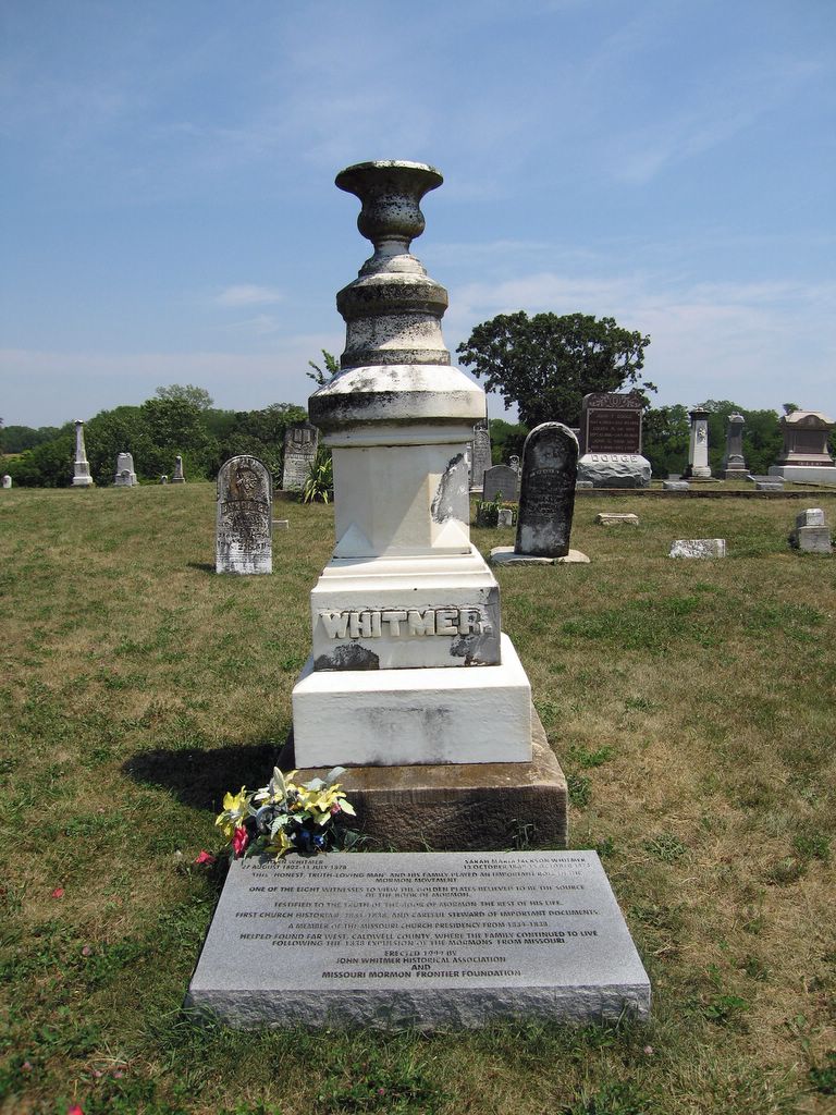
This is the Whitmer family tombstone in the cemetery at Kingston, Missouri, a few miles east of the Whitmer home at Far West, Caldwell County's original county seat. The granite tablet at its base was placed during 1999 by the John Whitmer Historical Association and the Missouri Mormon Frontier Foundation.
John Whitmer's grave at last
Now let's see, I left the Far West Temple site in Caldwell County, Missouri, several weeks ago and headed for John Whitmer's grave --- then got distracted. Well here we go again.
One of the fascinating aspect of early Mormon history is the fact that power struggles and disagreements between Joseph Smith Jr., trusted lieutenants and his successors as prophet left many of the most important early figures in development of the church rolling around in the dust along the way, excommunicated and scorned as the church reinvented itself in Utah.
John Whitmer (27 August 1802-11 July 1878) was one of the more important among these "dissidents." He, along with his parents Peter and Mary (Musselman) Whitmer, brother David Whitmer and other family members were among the earliest members of the church. Translation of the Book of Mormon was completed in his parents' home with John's brother-in-law Oliver Cowdery as principal scribe (John himself was a lesser scribe of this and other revelations). The church itself was organized in the Whitmer home. David was one of the Three Witnesses to the Book of Mormon and John, one of the Eight Witnesses.
The Whitmers, David and John, rose to places of great importance in the emerging church in "Zion" (Missouri). David eventually was named president of the Stake of Zion with John and W.W. Phelps as counselors. John was the church's first official historian.
Then, kaboom, Joseph Smith Jr. lost control in Kirtland (where church headquarters had remained) and pursued by a nasty banking scandal took himself, his lieutenants there and most church members remaining in Ohio during 1838 to Far West, founded in Caldwell County by the Whitmers, Phelps and the Missouri leadership.
A nasty leadership struggle ensued, actively encouraged by Sidney Rigdon, among the nastiest of the prophet's Ohio lieutenants. There seem to have been all sorts of motives here. One simply was that the Missouri presidency was accustomed to running Missouri, and arrival from Ohio of another leadership team generated instant conflict. The Ohioans had lost control in Ohio to dissidents, and were determined that it wouldn't happen again. The Missourians, in turn, were not happy with some things that had been going on in Ohio, including the banking fiasco and, reportedly, the prophet's new plural marriage revelation which apparently became common knowledge among top leaders. That, the Missourians felt, was adultery, not revelation.
The Missourians had opened themselves to charges by doing a few things they probably wouldn't have done had they known what was coming --- purchasing land in Caldwell County for the church in their own names, for example. That opened them to charges of profiteering.
When push came to shove, the Ohioans prevailed and all the Whitmers, Cowdery, Phelps and others were excommunicated. They remained at Far West for a time, then old Sidney delivered his "Salt" sermon, interpreted as a death threat by the dissidents and backed by the newly-organized and probably quite nasty Danites. The dissidents, including the Whitmers, fled.
After the 1838 Mormon War ended disastrously for the Saints and the majority fled east, coming to rest finally at Nauvoo, John Whitmer returned to his farm at Far West, acquired other property (including the Temple site) and settled down to life as a successful farmer. He also wrote the first history of the church, carrying it up to the point he was separated from it.
Upon his death during 1878, John was buried in the cemetery at Kingston --- created to replace Far West as the county seat because of its central location --- and he rests there today with his wife and other family members.
Kingston is one of those odd towns, not uncommon in Missouri, where the courthouse, other government offices and a brand spanking new jail seem to be the only justifications for its existence. It has a couple of hundred residents at the most.
The cemetery is located on a point of land in northeast Kingston. If you enter northward on the eastern-most drive and keep watch to your left, you'll eventually see a sign pointing to John Whitmer's grave on one of the highest points in the cemetery. The vintage family tombstone has been supplemented by a new granite tablet explaining in very diplomatic language his role in the early Mormon church.
As the years have passed nearly all historians --- including those devoutly Mormon --- have acknowledged that John Whitmer was an honest, honorable man caught up in a power struggle. You don't have to look too far, however, to discover that it's still OK to take snarky potshots at him.
It's useful to remember that John, although estranged from the church he helped to create, never questioned the legitimacy of the Book of Mormon or of Joseph Smith's prophetic stature. So in many senses, he was a Saint to the end.
It's also interesting to note that Sidney Rigdon took a nosedive into the dust himself when he decided that he, rather than Brigham Young, should lead the Saints after Joseph Smith Jr.'s murder. Kind of divine justice, that.
If you stop by to see old John, look to the right as you're driving along toward his grave and say "hey" to my Rhea cousins, also buried here. William, Bettie and their family arrived several years after the Saints had departed, but I've always thought it interesting that they ended up here at all.
Wednesday, September 21, 2005
Hanged by the neck until dead
 |
| Ivan L. Sullivan was hanged for muder of a prison guard at the penitentiary in Fort Madison on 12 November 1941. His grave is in Waynick/Holmes Cemetery southwest of Chariton |
Small towns have long memories, and so do I. It must have been junior high in Russell, playing "Did-you-know?" also known as "Gotcha," when someone dropped the bomb: "Did you know (insert name of fellow student here; I'm not a gonna do it)'s uncle was a killer? Hung at Fort Madison. Yup, it's true."
Soon after, I filed that away. Until two weeks ago Monday.
Envision a mildly ominous late summer evening --- yellow sky, windy, dust-dry, storm in the forecast --- at Waynick/Holmes Cemetery, an out-of-the-way place a couple of miles southwest of Chariton on a road now dead-end because some damn-fool drunk decided to lead the deputy on a chase over the graveled hill onto dirt, roar across the Chariton river bottom and slam into the rickety old river bridge, ruining it entirely.
We'd gathered there, the Lucas County Genealogical Society, for supper atop cemetery hill against the south fence, then a tombstone tour led by Mary Ruth Pierschbacher, descendant of the Holmes family who purchased the old Waynick farm surrounding the cemetery more than a century ago and whose graves are as numerous there as are those of the Waynicks, now vanished entirely from Lucas County. Mary Ruth grew up there, lived her married life there, her son lives there now and her late husband, Lloyd, is buried there.
Mary Ruth had conspired on supper with her cousin by marriage (and my cousin by blood) Mary Lou Pierschbacher, reminding us again why middle names are useful.
As we sat circled around an isolated grave, Mary Ruth arose: "This is Ivan L. Sullivan, hung at Fort Madison," she said. Yup, it's true.
I've been to Waynick/Holmes many time. My great-great-grandmother, Eliza Jane (Brown) Dent/Chynoweth, is buried there with her second husband, Joseph Turner Chynoweth; their daughter, Mollie; and a good many other kin and almost-kin. But I'd not thought about that isolated and sunken grave in the southwest corner before.
Mary Ruth went on to explain that Ivan's dad came out to see her dad not long before Ivan was executed, explaining that his Lucas County family planned to claim the body, but had no money and didn't know where to bury him. "How much would it cost to bury him here?" he asked of Mary Ruth's dad. And her dad replied, "nothing more than the cost of opening and closing the grave." And so this is where Ivan rests, quite alone but with a decent tombstone installed by the family that loved him despite crimes that spiraled from cattle theft through robbery and kidnapping to murder.
"I was about 6," Mary Ruth said, "and wanted so badly to stay at home and watch them bury him." But her parents would have none of that and off to school she went.
Visiting a week later with Betty Cross, whose knowledge of Russell is all-encompassing, we connected Ivan and my junior high "gotcha." Ivan had married a Russell girl, then destroyed her dreams and his life for who knows what reasons --- the inexplicable nature of evil. That Russell girl's sister was my fellow student's aunt, and in that manner had acquired Ivan as an uncle several years after his 1941 death.
The following report, published on the front page of The Chariton Herald-Patriot of 13 November 1941, tells Ivan's story:
"Executed Wednesday at Fort Madison; Sullivan Service Here Today
"Private services were held at the Beardsley funeral home in Chariton this afternoon for Ivan Sullivan, who died yesterday morning on the gallows at the Fort Madison penitentiary.
"Simple burial services were conducted by the Rev. Father Charles O'Connor of the Sacred Heart church of Chariton. Interment followed in the Waynick cemetery, southwest of Chariton.
"Sullivan was hanged at 7:06 Wednesday for the murder of a Fort Madison penitentiary guard, Robert Hart, in an unsuccessful prison delivery attempt July 8, 1940.
"Numerous appeals by friends, relatives and social workers to Governor George A. Wilson to commute the sentence to life imprisonment failed. Another last minute appeal by George Stuart, Chariton attorney, to Gov. Wilson was also denied.
"Sullivan last week wrote to Gov. Wilson in a plea for a postonement of the execution until after Thanksgiving to make it easier for his family.
"Tuesday, Sullivan dictated a statement to reporters in which he continually expressed his innocence and blamed Warden Glenn Haynes of the Fort Madison prison and Gov. Wilson for his plight.
"He claimed that the warden had refused him an interview with the press until it was too late to do any good. Ivan also claimed that had he been able to have an investigation in time, the bullet which killed Hart would have probably proved his innocence.
"The prisoner maintained throughout his long statement that the failure of the state crime laboratory to produce the murder bullet made him more certain than ever that Hart was killed by another guard's gun.
"Throughout the long statement, Sullivan rebuked the governor for not having answered pleas of his family to see the bullet.
"He said, 'A governor who tolerates such an injustice must indeed be a fine Christian.'
"Sullivan joined the Catholic church about six weeks ago, converted by Father H. V. Bongers, Fort Madison priest.
"One Chariton man was among the 165 official witnesses who attended the execution which was held in the prison yard near the point where Sullivan shot Hart.
"His life of crime started in 1933 at the age if 21 when he was sentenced to five years in Aamosa reformatory for cattle stealing. He was in Fort Madison under a 30-year sentence for robbery and kidnapping when he and two others made their prison break.
"Later, Sullivan and Lowell Haenze, who escaped with him, returned to attempt the release of William Cunningham, who killed himself when the attempt failed.
"It was during this encounter outside the prison walls that Hart was shot. Haenze and Sullivan escaped and spent the ensuing weeks in a series of crimes including numerous automobile thefts, filling station and other holdups and burglaries and the robbing of banks at Wilber and Diller, Nebr.
"It was after the bank robberies that Haenze was shot and captured at Marysville, Kan., July 19, and Sullivan was taken without resistance near St. Joseph, Mo., the following day.
"Sullivan pleaded guilty to the murder of Hart and was originally scheduled to be executed in September. His lawyers attempted to get the supreme court to grant a retrial of the case, and the execution was postponed at that time.
"The supreme court, however, denied the retrial and Gov. Wilson set the new date of execution."
Thursday, September 15, 2005
Fiddlesticks: Prather Cemetery Revisited
Let's see. I was on the road to John Whitmer's grave when last heard from --- before another week of vacation interrupted the logical sequence of things. Add another week to recover from chasing Robert Rathbun (died 1856) through Van Buren County and other side trips, and here we are. Back to John Whitmer another day.
I've rewritten and republished a May 19 piece about Prather Cemetery, located east of Chariton in Cedar Township. Like many amateur historians (and a good many professional ones, too), I was operating with incomplete information. Originally, I suggested Prather might actually be the cemetery founded about 1850 by William McDermott, Cedar Township's first settler, and sometimes referred to (logically enough) as McDermott Cemetery. Well!
While slogging through Lucas County's "Abstract of Original Entries" and assorted Cedar Township deeds the other day, I found enough to satisfy myself that the cemetery McDermott founded actually is what now is known as Bethel. The difficulty was, he thought he founded the cemetery on land he owned, but didn't. The oldest part of Bethel actually was on land purchased from the government by my great-great-great-grandmother, Elizabeth (Rhea) Rhea/Etheredge/Sargent, and her second husband, Thomas Etheredge.
This explains why, during the early 1870s, Elizabeth and her third husband, Edward E. Sargent, deeded the oldest portion of Bethel (for $1) to the township trustees for use as a public burying ground. I hadn't found prior to last week the deed executed at about the same time by William and Nancy McDermott, transferring a half acre of the newer part of the cemetery to the trustees for the same purpose. Together, these two small tract of lands form much of the current Bethel.
I'll get around to more about William McDermott, Bethel, etc., another time, but before doing that wanted to go back and clarify the earlier post about Prather Cemetery.
It now seems almost certain that Prather (called that only because Prathers owned the land around it at a time when someone decided it should be called something other than "that old abandoned cemetery") began as a family burial ground for the original owners of the land, James and Elizabeth Roland. Their daughter, Nancy, recognized as the first non-native child born in Lucas County, died during 1852 and hers is the first marked grave remaining. A Roland son also is buried there. As time passed, a few neighbors chose to be buried near the Rolands, but most opted to use what has been known variously as the McDermott, Sargent and Bethel Cemetery.
So the May 19 post now reflects this new information, and I'll turn left and head for John Whitmer's grave next time.
Friday, August 26, 2005
Far West, then on to John Whitmer's grave

The area that would have become the Far West Temple is marked by four massive cornerstones and enclosed by a wrought iron fence.

Memo to self: Re-read Fawn M. Brodie's 1945 "No man knows my history: The Life of Joseph Smith." I dated the copy I now have (Second Edition: Revised and Enlarged) 10 January 1989. So it's been more than 16 years. I've spent the morning reading reviews and retrospectives of Brodie's blockbuster, as opposed to doing something useful, so might as well return to the real thing.
Like it or not, "No man's" publication was the definitive 20th century event in Mormon studies. Mormons hated it. Non-Mormons loved it. The truth lies somewhere in between. It's helped to shape nearly everything written since about Mormon history by Mormon and non-Mormon alike. Besides, it is so wonderfully written that it reads like a novel (which some critics have suggested it is).
Memo to others: If you're going to become a Mormon trekker, buy the latest version of Becky Cardon Smith's "The LDS Family Travel Guide." It's updated annually. In addition to telling you how to get to places, it helps to see the high and low spots of Mormon history through Mormon eyes. And that's useful. For the Midwest, you want the "Independence, Nauvoo and Winter Quarters" version. There are other versions for other regions.
After dusting myself off, I left the Far West Cultural Center, wound my way back to pavement and headed about four miles straight north to the site of Far West. The site is high prairie, empty now save for the LDS Temple Site memorial and a Community of Christ (formerly RLDS) church off to the southwest.
The Mormons began arriving here, in Caldwell County, soon after the county was created for them during December of 1836 after much unpleasantness in Jackson and Clay counties to the south. Far West was designated the county seat and remained such until after the Mormon expulsion, when the more centrally located Kingston was created.
As planned, Far West would have rivaled any Missouri city in size and scope. Originally headquarters of only the Missouri Stake it became the headquarters of the entire church during the spring of 1838 when financial and other troubles ripped apart the Mormon community and church headquarters in Kirtland, Ohio, leaving the temple there in dissident hands. Joseph Smith and family fled here, to Zion, during March of 1838.
As Mormon immigrants continued to flood into Caldwell, then adjoining counties, tension mounted and erupted in what we now call the Mormon War. The surrender of Far West on 2 November 1838 marked the end of the 19th century Mormon dream in northwest Missouri. Joseph Smith left the city under arrest and a majority of the Saints fled, coming to ground again after a year or so had passed in Nauvoo. Then, Far West vanished for more than a century.
But beneath the prairie, the cornerstones laid for a temple to replace the building lost in Kirtland remained. Latter-day Saints purchased the temple site during the early 1970s, excavated the cornerstones and developed the current memorial.
It is a wonderful, quiet place with broad prairie views in all directions. I first visited here with my parents during the early 1970s, not long after development began. It's been interesting to watch it develop, and some Mormons expect that church authorities might someday authorize construction of a temple here to fulfill the original dream. I rather hope not.
A fenced and carefully landscaped enclave is about the size the temple would have been. The cornerstones now have glass covers and explanatory plaques. Huge stone panels at the east end repeat revelations relevant to the the temple and the Missouri experience.

There almost always are Mormon pilgrims here, if you wait a bit, but it's rarely crowded (except when a tour bus comes in off Interstate 35 some miles to the west). I shared my visit during early August with an extremely pleasant young family from Utah, making its first trip via Independence, Far West and Adam-ondi-Ahman to Nauvoo. It's been said (inaccurately) that Mormons have little theology but much history. What they do have, is an intense consciousness of and interest in history, and the parents in this instance gathered their children on the curved benches before the revelation panels, read the inscriptions, read accounts of what had transpired here from a guide book, then visited each point of interest within the temple in turn. And finally, I fumbled with their camera so they would have a photograph of the entire family together within the temple enclave to take away with them.
They were headed north from Far West to Adam-ondi-Ahman, where Joseph Smith declared following a revelation Adam had lived after expulsion from the Garden of Eden (at Independence) and where "Adam shall come to visit his people, or the Ancient of Days shall sit, as spoken of by Daniel the Prophet."
I headed east instead, to Kingston to visit the grave of Book of the Mormon witness and Mormon historian John Whittmer, then finally to Haun's Mill.
Thursday, August 25, 2005
Still on the trail (Mormon, that is)
Please note that the Far West Cultural Center no longer exits as a physical place. The Far West Cultural Center Web site, which contains a wealth of resource information, still is available.

This is the welcome sign at the Far West Cultural Center southwest of Mirabile, Caldwell County, Missouri.
Time flies when you're having fun. August began with a week of vacation and will end the same way as we all scramble to comply with our corporate master's not-so-benign "use-it-or-lose-it" time off policy before the end of the fiscal year.
Any trek down the Mormon Trail, and that's where I've been this summer, leads me inevitably to a research project that's been ongoing for many years: Trying to figure out the circumstances that resulted in the southeasterly townships of Monroe County, Iowa --- Pleasant, Mantua and Urbana --- becoming from 1843 until as late as 1866, when the last of the refugees arrived, an enclave for members of the Church of Jesus Christ of Latter-day Saints, nearly all of whom abandoned that pioneering and consumately American faith.
These "refugees" range from my own great-great-great-grandparents, William and Miriam (Trescott) Miller and their large family, to Lucius Augustus Snow, brother of Lorenzo Snow (fifth president of the Mormon church) and of Eliza Roxey Snow, a towering figure in the church and a plural wife of both Joseph Smith, the prophet, and of Brigham Young, the "American Moses." (Many members of the Community of Christ --- formerly Reorganized Church of Jesus Christ of Latter Day Saints --- maintain that Joseph Smith neither promoted or practiced plural marriage and therefore deny that Eliza was married to the prophet.)
I've been focused during August on two apparent key figures in this business, Robert Rathbun (early Mormon high priest and blacksmith) and his brother-in-law, George Miller, brother of my ancestor, William. Both died in Iowa: Robert during 1856 at Iowaville in Van Buren County and George, during 1875 in Mantua Township, Monroe County. If either could speak, many mysteries would be solved. Both apparently were pioneering Baptist preachers in Ohio who followed another towering LDS figure, Sidney Rigdon, into the emerging Disciples of Christ (or Campbellite) fold and then launched themselves into the early Mormon church. Robert's son, Hiram, maintained that his father and uncle (George Miller) were instrumental in Rigdon's conversion --- but that is a claim that I suspect would be disputed.
Whatever the case, the key events that led to the Monroe County settlement began in Caldwell County, Missouri, during the Mormon War of 1838, so that was where I headed first during early August.
My first stop, 80 or so miles south of Lamoni on Interstate 35 and after a left turn at the Wallace State Park exit onto narrow, twisting and scenic state roads, was the Far West Cultural Center just outside the tiny Caldwell County town of Mirabile.

Enter the cultural center gate and climb a hill to the Wash House visitor center and gift shop. As I said, everything here is very plain. The Wash House lacks even screen doors, so wasps were tormenting (although not stinging) both the guide and her guests.The 1837 log cabin is up the hill behind the Wash House.
If you're planning a visit, it's useful to keep in mind that the Far West Cultural Center is more of dream than reality (although they do have a wonderful Web site). Located back in the woods southwest of Mirabile off twisting gravel roads, it is very plain, consisting of the bedragled remains of the 1837 Charles C. Rich log house (concealed for more than a century within what appeared to be a far later farm house), the Wash House gift shop and visitor center (an old wash house moved to the site) and a few surrounding acres.

These are the bedragled remains of the log house Mormon pioneer Charles Rich built for his family during 1837. For nearly a century, it was concealed at the heart of a newer-looking farm house and was discovered by accident. Most traces of later additions have been removed. The metal frame supports a canvas that protects the remains during inclement weather. Are there plans to restore the cabin? No. The Cultural Center intends only to stabilize and protect what remains.
The log house probably is the only remaining Mormon structure in Caldwell County, set aside specifically for Mormons during late 1836 and site of Far West, which Joseph Smith and church leaders envisioned briefly as the equivalent of later church headquarters cities, Nauvoo, Illinois, and Salt Lake City, Utah.

Digs at the log house site confirmed that it had been built there rather than moved from another location. Two notching patterns on the logs indicated the cabin had been raised slightly at some point to allow insertion of a hardwood floor above the original dirt. The cabin was built using "V" notches, evident here where the top logs join at the corner. When the cabin was raised, new layers of logs using dove-tailed notching (evident on the corner link between the lower logs) were added.
And the cultural center is a logical dream because there is no other interpretive or visitor center in Caldwell County, of great importance in Saintly history, and it does seem like there should be one.
And the cultural center is a logical dream because there is no other interpretive or visitor center in Caldwell County, of great importance in Saintly history, and it does seem like there should be one.
But as I said, it's very plain --- and that seemed to disconcert an LDS family there at the same time I was, fresh from the expensively restored and carefully polished Nauvoo. It could be a cultural shock to come from "there" to "here," but that rustic site near Mirabile probably gives a more accurate view of what life was like for our pioneering ancestors than Nauvoo does.
So I loved it --- poking around the log cabin remains, peering down the hand-dug, fieldstone-lined well, contemplating the locust trees planted by Mormon pioneers because they grew quickly and produced needed wood. And in the "Wash House," I found and bought a coy of Clark V. Johnson's and Ronald E. Romig's "An Index to Early Caldwell County, Missouri, Land Records," which helped to make my day.
From the cultural center, I twisted my way back to Mirabile, then north a few miles to the site of Far West itself and the LDS-owned and maintained temple site memorial.
Subscribe to:
Posts (Atom)