 |
| About a third of the way down Olmitz Hill in the autumn. |
It's impossible now, 100 years later, to envision the view of the Cedar Creek valley that would have opened during June of 1917 as Chariton Leader editor Henry Gittinger and his companion navigated their vintage vehicle down the steep north-facing slope of Pleasant Township's "Olmitz Hill."
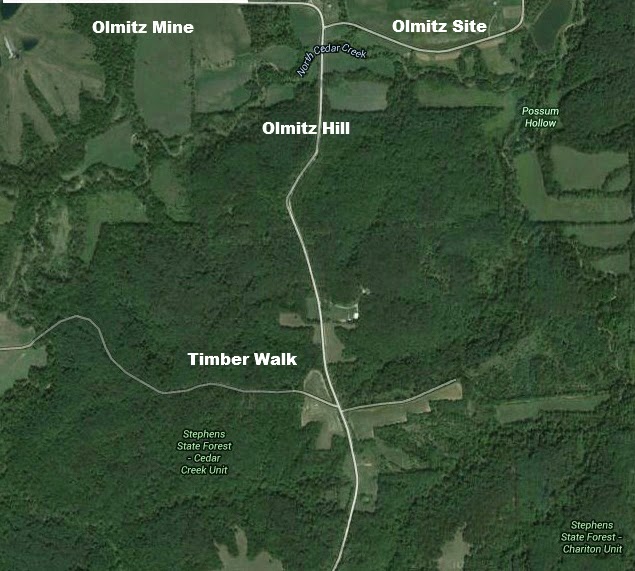
Up the valley to the left were the stacks of Central Iowa Fuel Co.'s Mine No. 3, also known as the Olmitz shaft, which had opened a year earlier; down the valley to the right was the mining camp of Olmitz, occupied by hundreds of miners and their families. Olmitz had sprung up during 1915 as Central Iowa Fuel's Mine No. 2 (Tipperary) was opening up just over the hills to the northeast. A branch line of the Rock Island Railroad connected all three. There was a smaller mining camp at Tipperary, too.
Olmitz was a family place with room to spread out along the valley floor. Tipperary, its site more constrained, was smaller and rougher and tougher --- gambling, bootlegging and goodness only knows what else thrived there.
All of this has vanished now, save the monument erected by the Braida family at the old Olmitz village site to commemorate its existence. But it's entirely possible to retrace the route of the road trip Henry proposed in his leader of June 28, 1917, through what was then --- and still is --- some of Lucas County's most scenic territory.
Just drive east out of Chariton on Auburn Avenue, past what now is Lake Ellis, then wind northeasterly up hill and finally down into the valley to join up with what now is a paved road sometimes known as the "Squirrel Road," at other times as "the road to nowhere." Climb the hill to your right, take a left once you've figured out where Dickerville School once stood, then wind north through what now is the Cedar Creek Unit of Stephens State Forest to Olmitz Hill, the valley and the territory beyond.
Here's Henry's text. And be warned, he was waxing poetic in this piece and it is sometimes a challenge to navigate your way through his florid prose.
+++
Did you ever traverse the Olmitz way --- just ere the gloaming set in and the timber denizens sought their perches in the higher altitudes of the forest primeval? Ever travel that trail in an automobile speeded just right, with congenial companions on pleasure bent --- or missions of benevolence, which amounts to the same thing? If not, you have missed much. It is one of the finest among the many automobile trails in Lucas county, and the scenic beauty cannot be surpassed --- if your eye is not blinded to nature.
To the north and east from Chariton you go by the winding way, through the sylvan dell, across the bridge on the miniature river, thence up the yellow slope and over the divide past the big city reservoir (Lake Ellis) --- and on through the landscape of farms teeming with life and enterprise, by the Schreck homestead and its new farm buildings, after leaving the Littleton country seat in the rear, then dropping down the rugged incline into the shadows of the vale, across the brook and thence from the opposite brink around a graceful turn to the east and thus you speed until you reach the Dickerville school house, whose history for learning dates back over decades, with smooth surface and well defined track all the way.
Here a turn is made due north and you follow the ridge as the eye scans the miles of verdant landscape on either side, with hill and glade and dell at this season of the year full of joy and yet profound in its pristine splendor, until you come to Cedar Ranch, or rather the villa nestling like a feudal castle upon the crest, where our friend W.V. Baker formerly dwelt and rejoiced in the freedom of rural life.
From here the timber line draws nearer to the trail and you pass under a canopy of branches, gracefully forming an archway through which the gleams of the rising moon occasionally penetrate and nuggets of light fall as though wrought of pearls. But when you reach the top of the slope which leads you to the dimly depicted town distances beneath and perhaps a mile down the valley you halt, because it seems almost as a leap in the dark.
Over to the west the big stacks at new No. 3 (the Olmitz shaft) may be discerned lazily discharging their coils of smoke as though emitted from a volcano. Far to the northeast, you cast your eye and the location of big No. 2 (Tipperary) is shown upon the panorama by the rising steam and distant rumble of machinery, while almost at your feet nestles the city of Olmitz, with its cluster of brown gables and houses in monotony of architecture.
Finally courage returns and the descent is made without accident, but one cannot help but shudder in contemplation of what might have happened had a land craft been met on the upward trip, so narrow is the way. In this respect the road to Olmitz resembles the way the scripture describes and over which so few travel.
The Leader challenges anyone reading the above description to deny that the writer has traversed the Olmitz way. It is certainly a picturesque country over in the heart of Pleasant, where home comfort abounds and nature has not yet been ravished of her beauty. There are fine cultivated fields and homes and orchards and native woods --- and interesting people. What more could one desire?
From a position upon the hilltop all this appeared as an immense picture painted by the hand of nature, and so it was except here and there art had gotten in a few touches where a fence defined itself along the angle, a gleam of cultivated field spreads itself upon the landscape or a chimney or roof might be discerned through the tree tops. But should you ever pass to this region do not be misled to almost ship-wreck by the siren voice --- by the words of honest friends, who had only traveled the way once. We have had experience, neither is longer a mystery.
Despairing the skill of the chauffeur to surmount the hill on the return trip without accident, or at all in the gloaming, the advice of a dweller to the north was taken, that "the northern route" be taken; that in returning via the C.R.I.&P. reservoir (now Williamson Pond) and Gunwald (now Williamson), the big hills were all gone down, not up. It may have been so. We have no enmity against our friend --- and the road may have been levelled down since then --- but we hope his journey to heavenly bliss may be beset with fewer obstacles.


No comments:
Post a Comment