

I was really happy the other day to learn that the Library of Congress had started digitalizing and placing online its collection of Sanborn Fire Insurance Maps, including the three earliest series from Chariton --- 1883, 1893 and 1899.
These large-scale maps of the business districts, industrial zones and some residential areas of thousands of U.S. cities large and small were produced between 1867 and the mid-20th century for the benefit of fire insurance companies and underwriters.
Since Mary Stierwalt has been sharing via Facebook history of the shoe stores, including her own Family Shoe, that have occupied the south half of the Hickman Block (above) since it was built on the east side of the Chariton square during 1894, I thought it might be fun to use Sanborn maps to show how the east side of the square developed between 1883 and 1893.
Attorney Stephen D. Hickman built the Hickman Block during 1894 after a fire had damaged earlier frame buildings on the site. When this photo from the Lucas County Historical Society collection was taken shortly after the building had been completed, the Hickman law offices occupied the north suite of offices upstairs and W.B.E. Lusk, a tailor, rooms to the south. Weiford Shoe Store --- now Family Shoe --- occupied the south side of the first floor; Alexander & Co., Grocers, the north half.

Here's how the east side of the square looked in 1883. Pink, on these maps, indicates that a building was constructed of brick; yellow, of frame. I've labeled the two frame buildings that sat then on the site of the Hickman Block. Note that both were grocery stores. The only brick buildings on the east side of the square at the time were in the north half of the block --- the Gibbon Drug Store at the far north end, the Mallory & Law Block immediately to the south and what now is the pet shop (the oldest building still standing on the square), just north of the alley. "Mill'y & Notions" on these maps is an abbreviation for Millinery and Notions.
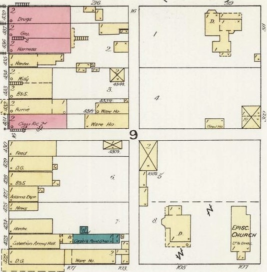
Ten years later, the east side of the square hadn't changed that much. The surprise (to me at least) here was that a one-story frame building on the north half of the current Eikenberry-Crozier Block site was at the time a Salvation Army Hall.

There was a major building boom on the east side during 1894, evident in this map from 1899. With one exception, the north half of the east side now was entirely brick and the Eikenberry-Crozier Block now formed the south end of the block
The "B&S" label on the south half of the new Hickman Block means "boots & shoes." A plumbing and bicycle shop occupied the north half of the building. Note the "Public Library" label on the Gibbon Drug building --- by now the Chariton Free Public Library had found its first home upstairs.
If you're interested in taking a look at the three series of Sanborn maps for Chariton (or maps from any other city for that matter, although the Library of Congress so far has moved only a small fraction of its collection online), follow this link to the Sanborn Maps Collection page, click on "Collection Items," navigate down the left side of the page to "Location" and select "Iowa," then scroll until you get to Chariton.
The State Historical Society of Iowa also has available online a larger selection of Sanborn Maps, including 1907, 1913 and 1927. In order to access that collection, however, you have to apply for and receive an Iowa Library Serivces Card and sign into the web site with a 14-digit identification number.
The Sanborn maps are not protected by copyright and may be downloaded in various formats from the Library of Congress site --- but not from the Iowa site.
Here's how an entire map sheet --- one of two --- from the 1883 Chariton collection looks. For more detail, right click and open in a new window. Remember that Chariton streets had different names in 1883, so don't be confused by that.


No comments:
Post a Comment