Thursday, June 30, 2005

Along the Trace: Douglass Cemetery


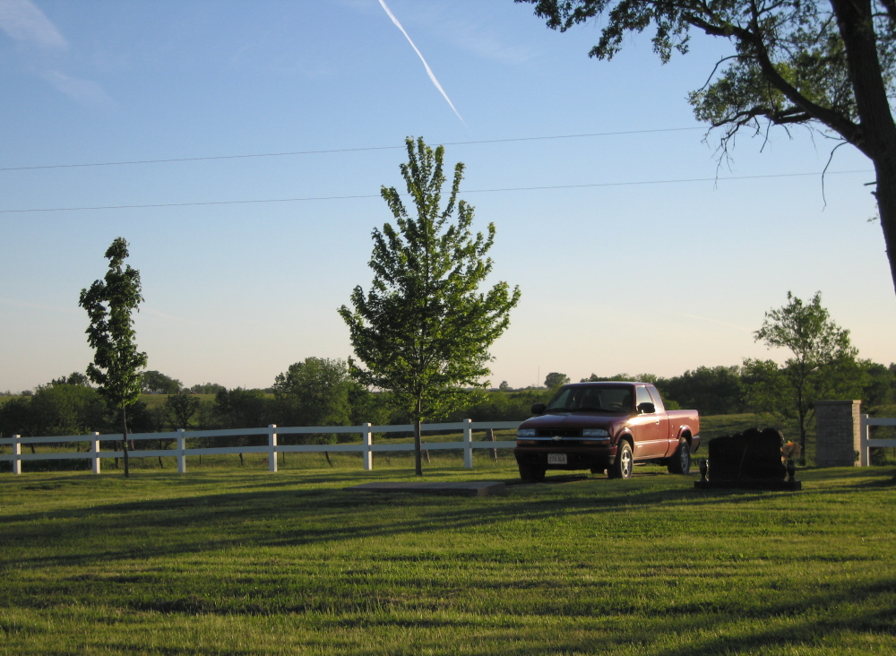
All tombstones found at Douglass Cemetery were gathered and grouped here, at the west end of the cemetery, after its rescue. The view is to the southwest. The most northeasterly bend in the Chariton River is perhaps a quarter of a mile or somewhat more over the brow of the hill and down in the distance.

To my mind, the old Douglass Pioneer Cemetery just southeast of Chariton and west of the Blue Grass Road may be the most evocative place in Lucas County. It encompasses Lucas County's history from beginning to the present in a way no other place quite does.

The name "Douglass" has nothing in particular to do with the cemetery other than the fact it once was surrounded by the farm of Noble Douglass. His home seems to have been located across the Blue Grass east of the cemetery, but there is no indication that any of his family is buried here.

There is no deed to the cemetery, although its ground always has been excepted in deeds conveying the property that surrounds it. There are no documents to explain its origin. It simply has been here as long as Lucas County has.

The most common explanation for its origin is that this was the site of the graves of Mormon pioneers who died at or near Chariton Point, most likely Elder Freeman Nickerson and members of his family who perished during the winter of 1846/47. Chariton Point became a consistently used camping point and minor way station during and after 1846 for those headed west from Nauvoo toward Utah. The Blue Grass Road, from Russell west then northwest into Chariton, follows almost precisely the route of the Mormon Trace, used by a majority of these refugees from early summer 1846 until about 1849. Lucas County's first "white" settlers were, according to tradition, a party of some six families, likely the Nickersons,  who wintered during 1846-47 at Chariton Point.

Chariton Point was the last major stopping point on the Trace before Garden Grove, a larger way station perhaps a day and a half's travel southwest in Decatur County, or Mount Pisgah, three or four days west of Chariton in Union County. Although the beauty of the Trace to Mormon eyes was that it went around the northern-most bend of the Chariton River near Chariton Point, rather than crossing the river, the passage at Chariton across ravines and a tributary could be difficult. So Chariton Point was a good place for teams and people to rest, preparing for a fresh morning start.

The Daughters of the American Revolution Chariton Point marker is three-quarters of a mile or so south of the cemetery, but no one really knows precisely where the reported log shanties and associated fields and gardens of Chariton Point actually were. The encampment area probably stretched all along the ridge, a distance of a mile and a half or so.

Mormon traffic on the Trace diminished as Nauvoo and nearby areas emptied and LDS families who had stopped in southeast Iowa to round up resources to equip themselves did so and moved on toward Utah, but the Trace continued to be a busy road as '49ers flocked to California and others used it to acess the unsettled West. The last record I've found of Mormon travel on the Trace was during 1853, when a Danish party that had come upriver from New Orleans disembarked at Keokuk, then headed overland on the Trace, camping near Chariton before continuing west to Utah.

Permanent settlers began to arrive in the Chariton area during 1848, and these pioneers probably began burying their dead near the first Mormon graves. This was a relatively common practice and the explanation for the existence of both Salem Cemetery, a couple of miles southwest of Chariton Point, and Last Chance Cemetery, at Lucas County's western edge, where Mormon pioneer Lafayette Sherwood, killed by stampeding cattle, reportedly was the first to be buried.


Here's the sign along the Blue Grass Road (Mormon Trace) pointing the way to Douglass Cemetery from the Blue Grass Road just southwest of Chariton.


To get to Douglass it is necessary to cross a privately-owned field and climb this slight rise. The trees at left are in the east end of the cemetery. The memorial area (barely visible here against the horizon), at the west end.

The oldest tombstones at Douglas date from 1852-1853 and the latest from about 1870, but the surnames of many of the 60 or people whose early burial here can be confirmed by tombstone or other sources are old and familiar in Lucas County: Ballard, Larimer, Dixon, Chase, Clowser, Hellyer, Wilson, Relph, Threlkeld, Renfro and more. There are indications, as in the case of John Relph, that families brought the bodies of their loved ones to Douglass from several miles away for burial because it was the nearest cemetery.

Then, probably not as abruptly as it seems, most Lucas Countyans stopped using Douglass. In all likelihood, they now preferred the newer Chariton Cemetery, established about 1863 a mile northwest on hills overlooking the Chariton River valley. Some graves were moved from Douglass to the new cemetery as were graves from the first cemetery established within Chariton's city limits, on the site of Columbus School.

Douglass Cemetery remained public ground, however, and Lucas County continued to use it for those who had no family or no funds and were buried at county expense. Hiram Wilson, the horse thief who shot and killed Sheriff Gaylord Lyman and was lynched for his trouble at the courthouse, was buried here by the county during 1870, for example. Most buried here between 1870 and the turn of the 20th century, however, were good people who were merely poor. Their graves were unlikely to be marked at all.

Because of its use as a burying place for the destitute, Douglass became known as Potters Field, and that is the name used most frequently by my father, who passed it frequently en route to and from his home in Benton Township, and most others of his generation.

Once Douglass was abandoned even as a burial place for the poor, all attempts to maintain it seem to have ceased. This continued for nearly 100 years and the result was not pretty: An overgrown enclosure of trees, brush and weeds in which only a few intact tombstones could be found.

Perhaps during the 1950s or 1960s, a house was moved from Chariton into the small field separating the cemetery from the Blue Grass, set back almost against the boundary fence. That helped Lucas County to forget the cemetery almost entirely.

Reclaiming Douglass was one of the first projects of the Lucas County Pioneer Cemetery Commission, established during the 1990s. The area was cleared of brush, weeds and dead trees and all tombstones that could be located were removed to a memorial area at the back of the cemetery and mounted on a concrete platform.


A bronze plaque at the memorial site lists the surnames of people whose burials at Douglas have been established beyond a reasonable doubt.

The cemetery is not fenced, so it is difficult for the casual observer to tell where it begins and ends, nor is the grass cropped short. But it is a vast improvement over the situation it was in during a majority of its history.

And if you're willing to walk the short distance back to it, Douglass is a good place to stand looking off to the woods and contemplate the dashed dreams of Mormon pioneers, Iowa pioneers and Lucas County's poorest --- all of which rest beneath your feet --- then remember their survivors who soldiered on.


This is the tombstone at Douglass Cemetery of Daniel B. Chase, who died Dec. 2, 1853, age 32 years, 1 month and 13 days.When the 1850 census of Lucas County was taken during December of that year, Daniel, single and born in Ohio, was living in the home of Henry Allen, a hatter. Henry reportedly lived on what now is the Chariton square and his cabin doubled as a hotel. Daniel married Mary Johnson in Chariton on 25 May 1851 (theirs was the 12th marriage recorded in Lucas County), then died two years later. When the 1850 census was taken, Lucas County had approximately 450 residents.

Saturday, June 25, 2005

Wonderwomen


Darlene Arnold

I don't mean to be sexist about this. A few men (including me) do wander into the Lucas County Genealogical Society's rooms at the Chariton Public Library now and then to help out. But most of the heavy lifting is done by wonderwomen who work miracles for researchers from across the country on a daily basis.

If I start naming them, I'll forget a few. So here are three who happened to be there when both the camera and I were last Monday.

Darlene Arnold is a hero. She has single-handedly indexed vital records, obituaries and other genealogically-useful articles in all existing Chariton newspapers, start to finish. This tool is available at the library and makes looking up obits and other information on microfilm a breeze.


Gwen Sims (left) and Lucille Chandler.

Gwen Sims has a long history of working on the Lucas County Genealogical Society newsletter, serving on the Lucas County Pioneer Cemetery Commission and undertaking virtually any other genealogical task that needs to be done.

And Lucille Chandler is a regular and familiar face at the library, doing what needs to be done and assisting researchers.

Thanks! You've surely made my obsessive-compulsive hunt for the odd details of Lucas County history far easier.

I took off down the Mormon Trail research-wise last week, and every time that happens I can't seem to bring myself to stop. But this has been an especially rewarding week that brought very promising leads that may allow identification of the pioneering Mormons who wintered 1846-1847 at Chariton Point --- Lucas County's first settlers --- then perhaps helped established what seems increasingly to have been a way station there, a destination that allowed Saints traveling the trail to regroup briefly before continuing on to either Garden Grove or Mt. Pisgah.

So I'm excited about that, and will keep you posted.

Note (added April 2011): Sadly, Gwen Sims is now deceased.

Wednesday, June 22, 2005

Rocks of ages: The Mormon Trace


This boulder with commemorative panel was placed during 1917 by the Daughters of the American Revolution at the first curve of the Blue Grass Road just south of Chariton. It marks the approximate location of the first permanent dwelling in Lucas County, along the Mormon Trace at a place called Chariton Point where Latter-day Saints families during 1846 made the first settlement by non-Native Americans in Lucas County.

I'm a sucker for Mormon shrines. The reconstructed temple at Nauvoo (glorious), Far West (wonderful), Garden Grove (chills just thinking about it), Mount Pisgah (wow!). Offer me a trek down the trail and I'll follow you anywhere.

I'm not sure why this is. Some of it's probably genetic, since I'm a member in good standing of an obscure and imaginary society dubbed "Almost-a-Mormon," and there are more of us in southern Iowa, especially in Monroe County, than you might think.

My ancestors William and Miriam (Trescott) Miller, converted in Ohio, trekked west with Joseph Smith to what now is Caldwell County, Missouri, but took a sharp left into southern Iowa when ornery Missourians chased the Saints out of there and most headed for Nauvoo on the Illinois banks of the Mississippi downstream from Fort Madison and upstream from Keokuk.

Uncle George Miller, brother to William, is credited by some with converting Sidney Rigdon, a major figure in early Mormon history, by convincing him (with aid from George's brother-in-law, Robert Rathbun) of the veracity of The Book of Mormon). George went back to Ohio after getting chased out of Missouri, but eventually ended up in Monroe County, too.

Once parked in Monroe County with a substantial contingent of other ex-Saints dubbed by some of their snooty neighbors "the hairy nation," the Millers wandered off spiritually into their original Baptist as well as the Brethren and Disciples of Christ folds, thus missing the Latter-day Saints boat.

So that's part of it.

Another part certainly is the fact that all Lucas Countyans grow up and live astraddle the Mormon Trace, a route used by a majority of the Saints as they headed for Utah commencing in early 1846 after being chased out of Nauvoo by the good people of Illinois.


This is the panel on the Blue Grass boulder just southeast of Chariton commemorating Chariton Point, where Mormon pioneers wintered during 1846-47.

The Mormon Trace doesn't get the respect it deserves, however, always coming in second in the hearts and minds of Mormon historians to what's called the Pioneer Trail, even though far more of their biological and spiritual forbears traversed the trace than the trail.

Here's what happened. When Brigham Young led the first band of Saints out of southeast Iowa during early 1846, he followed rough trails to about where Drakesville now is located, northwest of Bloomfield, then veered southwest through Appanoose County almost to the Missouri line before heading west through southern Wayne County, then gradually northwest to Garden Grove, in Decatur County, where hundreds of men labored as summer approached to establish the first way station for pioneers who would follow them.

This is now called the Pioneer Trail, rich in sentiment. Brigham Young trod it. William Clayon penned the great LDS anthem, "Come, Come Ye Saints," while camped along it southeast of Corydon.

But Young realized immediately that the trail he blazed was too rough and the river and stream crossings too difficult for further use. So he sent couriers back from Garden Grove, warning Saints who followed to take a more northerly route up the great prairie divide that bisects Lucas County.

And so from late spring 1846 onward, thousands of Mormon pioneers continued west from Drakesville through the current general locations of Unionville, Moravia and Iconium to a point just west of Iconium (in Appanoose County) called Dodge's Point.

From there, skirting the north banks of the Chariton River, the pioneers nicked Monroe County's southwest corner before passing into what now is Washington Township, Lucas County. The trail meandered up through the general sites of Greenville and Russell, then followed the course of what now is known as the Blue Grass Road past Salem Cemetery to the area just southeast of Chariton along the wooded east flank of a place called Chariton Point.

Chariton Point is called that because the Chariton River, rising in Clarke County to the southwest, flows northeasterly to the current location of Chariton, comes to a point, then turns sharply southeast along the wooded bluffs where many of those early Saints paused to rest.

The trains then continued up and around Chariton Point through what now is Chariton, then off southwest past Goshen and Last Chance until finally reaching the approximate site of Smyrna Friends Cemetery in Clarke County where it branched south to the way station at Garden Grove or west-northwest to a newer and larger way station at Mount Pisgah.

Many thousands of Saints passed through Chariton during the years 1846-49 before a fairly easy Chariton River crossing was discovered during 1849 southwest of Dodge's Point (a crossing now under the waters of Lake Rathbun). That crossing allowed the Saints to cut straight across northern Wayne County to Garden Grove, so use of the Lucas County trail diminished as the final Mormons of the great initial exodus headed west. It continued, however, to be an important route for other pioneers for many years to come.


This is the Mormon Trace interpretive marker on the shore of Lake Rathbun commemorating the shortcut that beginning in 1849 supplanted the Trace route through Lucas County that had served thousands of Saints.


This portion of the panel explains how the shortcut was discovered and the impact it had on the last of the initial wave of Saints moving through Iowa toward Utah.


The second portion of this panel section is a first-hand account of the discovery of the shortcut and the blazing of a more direct route to Garden Grove.

+++

Two giant boulders erected during 1917 by the Daughters of the American Revolution can be found along the trace in Lucas County. The first is located at the first curve of the Blue Grass Road just south of Chariton. It marks the general location of William "Buck" Townsend's log house, built on a claim that was among several pre-empted along the eastern flank of Chariton Point (the actual bend in the river is out of sight over the horizon to the west) by the first Mormons to reach here.

Perhaps as many as 30 people, including members of Elder Freeman Nickerson's extended family, wintered near here but right down alongside the river during 1846-47, then remained for some time thereafter to build log shanties on the prairie edge above the riverbend before moving on toward Utah. This was the first almost-permanent settlement in Lucas County by non-native Americans. Elder Freeman and a grandson died there during that winter and probably were the first to be buried in what now is called Douglass Pioneer Cemetery.


This boulder, placed by the Daughters of the American Revolution in the courthouse square during 1917, commemorates the location of Chariton along the Momon Trace during 1949.

The other boulder, supplemented by an informative LDS panel, is located in the southwest corner of the courhouse lawn, and marks the spot where Chariton was organized along the trail during 1849.


This is the memorial panel on the courthouse square boulder, noting the place where the city of Chariton was founded along the Mormon Trace during 1849.


The LDS commemorative panel near the DAR marker in Chariton's courthouse square provides the following general information: "Beginning in February of 1846, the vanguard of the Church of Jesus Christ of Latter-day Saints (the Mormons) struggled across southern Iowa on the way to their "New Zion" in the Rocky Mountains.

"The trek from Nauvoo, Illinois, to Kanesville (Council Bluffs), Iowa, tested the endurance of humans, animals, and equipment. The frozen landscape of an Iowa February soon turned into a thawing mixture of nearly impassable mud and muck. Their unshakable faith and determination sustained them, however, and thousands of men, women, and children arrived at the Missouri River, having completed this first portion of the journey west under extremely difficult conditions.

"After wintering in the present-day Omaha/Council Bluffs district, the Saints continued across Nebraska and Wyoming to the Valley of the Great Salt Lake. Today, a marked 1,624 mile long auto tour route closely parallels this historic route."


This section of the LDS commemorative panel in the courthouse square tells first-hand the story of how Grave Hollow, located just southwest of Chariton, got its name. Click on this and read it for yourself. Printed on the panel near it is this more general description of the event:

"Tragedy along the Trace: West of the city of Chariton, one of the scenic roads of Lucas County passes down through an area known as Grave Hollow, a declivity between the wooded hills, gradually sloping down to the Whitebreast River (actually Whitebreast Creek). Grave Hollow came by its name through an unfortunate accident.

"A family named Gabbut was making the long trek along the Northern Trace of the Mormon Trail in October 1846. After crossing the Chariton River, Sarah Gabbut tried to get back into her wagon but slipped and fell. Startled, the oxen bolted and the heavy wagon ran over her abdomen. She lingered for an hour and then died. The company carried her body until the end of the day's travel and buried her at their camp in Grave Hollow.

"Accidents with wagons and stock were common along the trail. Such events were usually not fatal for pioneer families, but they did cause many unfortunate injuries during the trek west."  
 
These rocks have been around so long and are so familiar, I'm not sure Lucas Countyans even see them anymore. But they are permanent reminders of the days when Lucas County's prairies were abloom this time of year as they rolled off toward the endless horizon, wolves still traversed the wooded creek valleys and trains of prairie schooners sailing west day after day were as common a sight as the coal trains that now roar along the Burlington Northern & Santa Fe tracks that parallel the trace in Benton Township.

+++

The other Trace-related marker at Chariton is an interpretive panel, canted so that you look up from it toward the southwest,  located south of the frontage road north of U.S. Highway 34, just in front of the Indian Hills Community College Chariton center. If it weren't for Highway 34, the Burlington Northern & Santa Fe railroad tracks and various Chariton Industrial Park buildings, you'd be able to see the Blue Grass Road, just the other side of the railroad tracks, as it angles northwesterly into Chariton. And that's the point, since this panel provides a good, concise explanation of the role the Mormon Trace played in the great movement of Latter-day Saints pioneers through south central Iowa to Utah.


This LDS interpretive panel is located in southeast Chariton, south of the frontage road north of U.S. Highway 34 and in front of the Indian Hills Community College Chariton center.


This portion of the LDS interpretive panel explains the role of the Lucas County route in the westward movement of Mormon pioneers. Click on the image and it will enlarge, or read the text here:

"The high ridge that is visible beyond this panel was heavily traveled by Mormon Pioneers starting in June of 1846. The southern route, used by Brigham Young's Pioneer Party, was soon abandoned for the more easily navigated Northern Trace. This route carried thousands of Mormons westward.

"The ridge they traveled separates the tributaries of the Missouri and Mississippi Rivers. The courthouse, which is on the horizon to your right, sits directly on top of this ridge. Water east of the courhouse flows into the Mississippi, and water west of the courthouse flows into the Missouri.

"The Northern Trace proved an easier route for the Mormon Pioneers to travel, but there was also another reason for staying north. Rumors of resurfacing hostilities with Missourians made the southern Pioneer route along the Missouri border appear somewhat risky. As the area developed, more roads and trails sprang up along the Northern Trace which the Mormons continued to use."

+++

I'm referring consistently here to the route through Lucas County as the Mormon Trace (rather than Mormon Trail) --- to avoid having Henry Gittinger come back and haunt me.

 Henry was a long-time Lucas County newspaper editor and publisher, first prior to the turn of the 20th century in Russell and then in Chariton, and a local historian to boot. His ancestors were among the first to settle down around Greenville (on the Trace) in Washington Township, so he felt that he had a somewhat proprietary interest in it.

Anyway, when the Iowa Daughters of the American Revolution memorials were placed during 1917, Henry was extremely miffed that they referred to the route as "Trail" rather than "Trace." He carried on and on about this in print and even tracked down and scolded Edgar R. Harlan, of the Historical Department of Iowa, who practically single-handedly first traced the Mormon route from Nauvoo and Kanesville (Countil Bluffs), for careless nomenclature. Henry's contention was that both the Mormon emigrants and the permanent settlers who followed them referred to the route as "Trace," not "Trail," and that to use the term "Trail" was inaccurate historically.

Well, Henry may have been right --- even Harlan acknowledged it. So in the interest of Henry's eternal rest, "Trace" it is.

It's also interesting to note that Harlan's tracking of the Mormon route entirely eliminated what now is known as the Mormon Pioneer Trail --- the briefly-used route blazed by Brigham Young through southern Wayne County to Garden Grove. When, during the 1930s, the state decided to mark the Pioneer Trail route at the expense of the route through Lucas County, Henry --- although quite elderly by that time --- was off and fuming again.

And I certainly sympathize. The Lucas County route doesn't get the respect it deserves. But it's very hard to compete with ground that Brigham Young, William Clayton, Lorenzo Snow and others had trod, even if relatively few Saints followed them down that particular branch of the "Trace."

Friday, June 17, 2005

The Clair/Clear Pioneer Cemetery


William Clair's lone grave is located at the edge of a field just inside Lucas County's north line southeast of Columbia. And if the fact the cemetery sign identifies William as "Clear" rather than "Clair" isn't confusing enough, consider the fact that William isn't actually buried here, but rather a few feet south.

This post originally was headlined "the Misspelled Pioneer Cemetery," but I've just now (as February 2011 is ending) changed it to reflect the fact this is more about the Clair family than it is about a variant spelling of the family surname.

 The difficulty with the Clair/Clear family name can be traced to my grandfather, William Ambrose Miller, who placed the tombstone on which the surname "Clear" is inscribed on the grave of his great-grandfather, William Clair/Clear, and caused no end of confusion by doing so. He did so because that was the way William signed his will in a firm, clear hand on the 10th of December 1852 --- even though there is no indication any member of the Clair family ever spelled it that way at any other time. I have no idea why William signed his name that way although I've sometimes wandered if someone else signed it for him --- but there's really no indication of that. The witness signatures and everything else about the will are in order.


When the Lucas County Pioneer Cemetery Commission decided to designate William's lone grave a cemetery, they quite logically picked up the spelling on the tombstone.

William's grave is located in Section 3, Pleasant Township, Lucas County, but the most sensible way to get there is to drive to Columbia, a little town just north of the Lucas-Marion county line. There's only one crossroads in Columbia, so head south when you reach it to the Columbia Cemetery curve. Travel about half a mile east of the cemetery, then a mile south. You've reached a "T" intersection with the county line. Turn left on the county line (right is a dead end) just a little, then follow the road south and start watching the west side of the road. Just beyond a small house on the east side of the road is a field entrance on the west side of the road, and just inside that entrance is William, sort of. He's actually not buried in the grave-size area designated pioneer cemetery, but rather about 12 feet south. That, however, is another part of the story.

The Clairs are the darndest family to work with. William and Mary were ramblers, always chasing opportunity and coming to rest in Iowa when quite old by standards of those days, having lived in the apparent state of their births, Rhode Island, then upstate New York, Ohio and Illinois. Most of their children reached maturity and married along the route and never reached Iowa at all. Eventually all of their descendants who did live in Iowa, other than my great-grandmother, Mary Elizabeth (Clair) Miller, moved on to Kansas and points west. There just isn't a collective memory of the family to fall back on.

William's dates of birth and death, 1790-1853, were scratched by hand deeply into the small sandstone slab that marked his grave originally, so Grandfather replicated those dates when he ordered the new tombstone during the early 1950s. His age is given as 64 in the 5 July 1850 census enumeration of Washington Township, Marion County, suggesting that he might have been born as early as 1786. Who knows? The census record also gives his place of birth as Rhode Island, although sons James Wayne and Zolomon Jones both reported in 1880 census enumerations that their father had been born in New York.

William Clair and Mary Sanders (or Saunders) may have married in Rhode Island, although no record has been found. They seem to have arrived in what is now Canadice Township, Ontario County, New Yourk, about 1813. There are reasons to believe they might have lived in Maine before that, but no proof. From there, the family moved to Ohio, then to Shelby County, Illinois, and finally during 1847 settled just east of what now is Columbia in Washington Township, Marion County, Iowa. William and Marry seem to have been accompanied to Iowa only by their youngest child and my great-great-grandfather, James Wayne Clair (9 October 1836-6 May 1894).

The family settled on a prairie farm just east of what now is the village of Columbia, but also purchased at least 160 acres of timber in the hilly, wooded area south of Columbia.

Another son, Zolomon Jones Clair (14 February 1823-27 November 1894), joined the family in Marion County not long thereafter, and it was he who purchased from the government the property just across the Lucas County line where William is buried.

Z.J. was quite a character. A veteran of the Mexican War, he had married on 10 April 1844 in Shelby County Sarah Ann Spidle. It's not quite clear who deserted whom here, but I have an uneasy feeling that it was Zolomon who took off. In any case, Z.J. and Sarah Ann were no longer together when Z.J. arrived in Iowa during 1848 or so and promptly entered an adulterous relationship with Delilah (Hinkle) Feagins, wife of the unfortunate Leonard. By some family accounts, Z.J. compensated Leonard for the loss of his wife (and probably a son, William Milton, who subsequently adopted the surname Clair) by giving him a shotgun.

Here's how Z.J.'s descendant David Hammer told the story: "A little story with this couple told by my grandmother: Delilah Hinkle (born in Ohio) married a Leonard Figgens. One day a sailor stopped by while hunting (Z. J. Clear) and Figgens admired his shotgun and told him he would trade his wife and son for the gun. Later one day returning home Figgins found the gun and no wife or son."

In any case, Z.J. promptly divorced Sarah Ann, alleging that she had deserted him. And Leonard divorced Delilah, citing adultery and desertion. These divorces were the first in Marion County and the case files are vastly entertaining --- although not always to descendants of Z.J. and Delilah who went on to have quite a large family.

Both Leonard Feagins and Z.J. Clair's mother, Mary, were charter members of Belinda Christian Church, just across the line in Lucas County, and it would be interesting to know what sort of play Z.J. and Delilah's affair got in that congregation and in the pioneer community around Columbia.

Zolomon and Delilah eventually married, on 12 February 1853 in Marion County, after the births of one or two children, then moved west through Kansas to Washington.

We don't know the precise date of William Clair's death, so Granddad had the death year 1853 transferred from the sandstone slab to the new tombstone about 100 years after the fact. William signed his will on the 10th of December 1852 with Larkin D. Fletcher and William A. Riddle as witnesses. His estate entered probate in Marion County 31 January 1853, so it seems likely that William died soon after the first of the year.

Burial was a do-it-yourself affair in those days, so some of the Clairs went into Knoxville during December of 1852 and purchased from from P. & P. Marker 10 yards of shrouding ($4.50), a pair of white hose (75 cents), 3 yards of bleached muslin (45 cents) and 6 screws (5 cents). Presumably William was wrapped in the shrouding and the white hose placed on his legs after death and his remains placed in a homemade coffin lined with the muslin and secured with the screws. The Markers presented a bill to the estate for these and other items during March of 1854.

There was no cemetery in the neighborhood at that time, and family stories hold that William selected his own burial place under a large tree on the land owned by his son, Z.J., southeast of Columbia. This also is the highest point in the neighborhood with sweeping views off to the east, and this may have been a factor, too.

Although my granddad knew only of the two Clair boys, James Wayne and Zolomon Jones, a portion of William's estate was disbursed in equal portions to eight children, Mary Stanwood, Rhoda Sinclair, Clarissa Butler, William Clair, Ann Casey, Zolomon J. Clair, Elizabeth Hart and James Wayne Clair. Over the years, I've managed to track down bits and pieces of information about these other children, but it has proved to be a daunting task. This was not what you'd call a close-knit family.

Mary Clair (born 7 January 1793 in Rhode Island) survived William by 24 years, dying on 10 November 1877. By that time, the village of Columbia had been established and Columbia Cemetery started just south of town. So the decision was made to bury her there, rather than out next to William on his hilltop. She rests there still along with two grandsons, William Richard Clair, who died 24 March 1874 at age 20; and Jasper Sylvester Clair, who died 22 March 1874, age 2 months. Both were victims of the measles according to Granddad, although a newspaper report attributes William Richard's death to typhoid.

William Richard and Jasper Sylvester were children of James Wayne Clair, who had married Elizabeth Rachel Rhea (27 February 1837-1 January 1922) on 20 January 1853. He was 16 and she was 15 at the time. These were my great-great-grandparents. Their daughter, Mary Elizabeth, the oldest girl among 12 children, married Joseph Cyrus Miller and was the only one of their children to remain in Iowa.

James Wayne and Elizabeth Rachel, according to my grandfather, ran into a spot of trouble with their creditors during 1878, packed their wagons and high-tailed it for Kansas with the rest of the family.

My grandfather, son of Joseph Cyrus and Mary Elizabeth (Clair) Miller, entered a mark-every-grave phase during the early 1950s, and William and Mary Clair and their grandsons, William Richard and Jasper Sylvester, were among the benefactors. But Granddad had a terrible time deciding how the Clair surname should be spelled on their tombstones, since it appears variously as "Clair," "Clear" and "Clare" in probate and other documents. He finally decided (and probably shouldn't have) to spell it "Clear" on William's tombstone out on the hill and Mary's tombstone in the Columbia Cemetery and "Clair" on the tombstone the boys share beside their grandmother. This has caused a good deal of confusion over the years and subsequent research has revealed that the family did spell the name "Clair" most of the time.

Columbia is a lovely and well-maintaned cemetery, so Mary and the boys rest easily there. William's has had a harder time of it. Various farmers have cultivated the land around his grave over the years and most have resented his presence. We tried to leave the original sandstone marker at the grave. It was run over with a tractor wheel, broken into several pieces and tossed over the fence into the graderditch. I found the largest fragment and took in home, where it resides in a flower bed.

Then various farmers took to simply moving the new tombstone around. We put it back. They moved it again. Unfortunately, it was in the wrong place when old William was declared a pioneer cemetery, and the stone was fenced where it lay, about 12 feet north of his grave's location. That's unfortunate, I suppose, but we eventually decided just to let sleeping dogs lay and get over it.

But if you visit, walk over to where he's really buried and say "Hey."

Wednesday, June 15, 2005

A Smith homecoming at Salem


Charles E. Smith's tombstone, restored to an upright position by Bill and Hazel Smith, who left the wild roses there as well.

I’m not given to fancies, but couldn’t help but envision Josiah and Sarah (Pitts) Smith standing by imperceptibly out at Salem Cemetery last week with gratified looks on their faces as their great-grandson, William B. Smith, labored for at least a day and a half to restore order to their burial place.


Bill and Hazel Smith.

Bill and his wife, Hazel, had driven to Iowa from their home on Vashon Island, just north of Tacoma, Washington, specifically for this purpose --- visiting relatives on the way to and from, taking a side trip into Putnam County, Missouri, to research Hazel’s family and eventually ending up this week in Gillette, Wyoming, for Hazel’s class reunion.


The spruce in question before the Smiths gave it a haircut.

The major problem out at Salem was a large blue spruce planted perhaps 50 or 60 years ago (we don’t know by whom) on the Smith lot (No. 50 in Salem’s southeast corner). It’s entirely possible a Smith family member placed it there to mark otherwise unmarked graves. Or some of the Johnstons, a family buried just to the west in Lot No. 49, may have strayed into Smith territory, planting the tree to shade their own lot.


The spruce trimmed to allow access to gravesites.

It is a lovely tree now, but blue spruces can cause trouble if not placed carefully and pruned appropriately. The spruce on the Smith lot now is very large, its boughs swept the ground in a wide radius obscuring everything beneath and those boughs, moving in the wind, probably were responsible for breaking the tombstone of little Charles E. Smith, who died 11 September 1878 aged 9 months and 19 days, off near its base and pushing it onto its back, allowing it to sink gradually into the earth.

Charles E. (Elmer) Smith was the 12th of Josiah and Sarah’s children and his grave was the only one marked on the lot, which also is the resting place of Josiah and Sarah, their daughter, Mary Ellen (Smith) Widaman/Dixon, and probably another son, William.

I sometimes call Salem “my” cemetery, since I intend eventually to spend a great deal of time there --- although in a somewhat altered state --- and so had known for years that some of the Smiths were buried in Lot No. 50, but it was not until several years ago when I met Roberta Tuller of Encino, California, a great-great-grandchild of Josiah and Sarah, that I learned who they were and something of their stories.

Roberta had begun pulling together distant and widely scattered Smith and Fox cousins, including Bill and Hazel and many others, in an effort to acquire, organize and delve more deeply into the histories of these families. Bill had been researching the family for many years, shared his wealth of information with Roberta, and I’ve been fortunate enough to learn a lot about the family from their collaborative effort. So credit for the genealogical information here belongs to Roberta and Bill.

Josiah Smith was a native Tennesseean, born there about 1825. He married Sarah Pitts (born 30 April 1826 at Blountville, Sullivan County, Tennessee) on 15 October 1846 at Blountville. The first seven of their 13 children were born in Meigs County, Tennessee. Those children were Elizabeth Jane (m. Andrew M. Frank), Allison Woodrow (m. Sarah M. Souders), Nancy Ann (m. Robert Lee Wilson), Mary Ellen (m. Charles F. Widaman,George W. Dixon), David H (m. Oraline), Josiah Allen (m. Eliza Fox; the great-grandparents of Bill and great-great-grandparents of Roberta) and John.

Josiah enlisted for service in the Mexican War on 7 November 1847, when he was 23, at Knoxville, Tennesse, and served in Co. C, 5th Regiment, Tennessee Volunteer Infantry, until honorably discharged 20 July 1848 at Memphis.

At the outset of the Civil War, he enlisted 1 November 1861 in the Confederate 5th Cavalry at Decatur, Tennessee. Taken prisoner twice during the ensuing years, he finally swore allegiance to the Union on 26 September 1864 and was paroled upon his pledge not to return south of the Ohio River.

It probably was soon after this that he wrote to Sarah, instructing her to sell all the family had left in Tennessee and bring the family north to the vicinity of Peoria, Illinois, where he had established a home for them. She did exactly that, and two more children were born to Josiah and Sarah while living in Illinois. Those children were George Washington Smith (m. Rosa Estella Arnold) and William.

During the late 1860s, Josiah and Sarah and their children came west to Benton Township, Lucas County, where they were living as neighbors to my Myers and Redlingshafer families when the 1870 census was taken.

Four more children were born to them in Lucas County: Ida Belle (m. Charles W. Hoops), Sarah Catherine (m. John A. Hoops), Charles Elmer and Cora Edna (m. Frank B. Downard).

Charles Elmer may have been the first of the Smith family to die in Lucas County (on 11 September 1878), and Lot 50 at Salem may have been purchased for his burial. There’s probably no way of proving this, since I haven’t been able to locate the deed to the cemetery lot. But since his parents took such care in marking his grave, I think they would have showed equal care had either of the other two “missing” boys, John and William, died in Lucas County prior to Charles.

By the time the 1880 census was taken, the Smith family had moved a few miles west into Warren Township and was living near Derby when disaster, in the form of typhoid, struck. Josiah died 16 September 1880 of that disease and was returned to Salem for burial beside Charles. Family stories suggest that son William also may have died of typhoid that fall, and if so he would have been buried at Salem, too.

Josiah’s death would have been devastating both emotionally and financially to his large family, now left without a provider. That loss probably explains in part at least why his family scattered so widely during the years that followed.

Sarah (Pitts) Smith died 31 years later, on 5 August 1911, at the home of her daughter, Cora (Smith) Downard, in Russell, and was buried by Josiah at Salem.

Daughter Mary Ellen died 13 January 1949 and chose to be buried at Salem beside her parents (her first husband, Charles F. Widaman, had died 31 August 1894 in a gold mine collapse in the West; and her second husband, George W. Dixon, who died 12 January 1945, was buried with his family in Russell).

Mary Ellen’s burial would have been the last made on the Smith lot at Salem.

As I said, these graves are unmarked. I suspect that Josiah, Sarah and perhaps William were buried just north of Charles, under the spreading boughs of that old spruce, and Ellen, perhaps, on the north end of the lot. But these things are very difficult to determine.

Visiting with Bill and Hazel in Chariton on Sunday afternoon, Hazel recalled that friends and relatives in Washington had remarked that returning to Iowa to repair a tombstone seemed to them just a little “crazy,” and that she wasn’t too sure about the idea herself.

Once at Salem last Wednesday and Thursday, Bill located the tombstone, proceeded to trim the spruce to a reasonable height off the ground, removed brush that had grown up in it, bought cement, poured a new base and finally restored Charles E. Smith’s tombstone to an upright position.

I’m not sure what those folks out in Washington think, but Hazel is now a full-fledged believer and so am I. What a wonderful thing to do.

After Bill and Hazel had driven off into the sunset Sunday, headed for Des Moines and then to Wyoming, I drove out to Salem and was struck afresh by what a lovely and peaceful place it is.

Hazel had remarked about the “the prettiest sunrise I’ve ever seen” early one morning out there among the graves of Bill's family and had noticed the wild roses flourishing in the fencerows.

Sunday evening, as the sun was setting in the west, some of those roses --- picked by Bill and Hazel and placed at Charles's grave, still were fresh.


The sunset view from Salem Cemetery.

Saturday, June 11, 2005

The Ottumwa Coal Palace


This old photograph is a good example of the fact you never quite know what's going to turn up in boxes of old photographs. Although completely unmarked, it probably was brought home to Lucas County as a souvenir of a visit to the palace, the most spectacular celebration of Iowa's coal industry ever launched. Lucas County was one of the 12 coal-producing counties that --- along with Ottumwa business interests --- contributed cash to fund it.

Since it's not that obvious now, you have to know the territory to realize that for many years coal and farming were the twin supports of Lucas County's economy. Mining towns such as Olmutz, Tipperary, Cleveland and Zero have vanished entirely. Mining boom towns such as Lucas and Williamson have declined. And you have to know where the mines were in order to locate them since few obvious traces remain.

But the coal industry was rising during 1890 when the coal palace was constructed in Ottumwa to house a two-year regional exhibition to advertise and promote sounthern Iowa as one of the nation's top coal-producing, agricultural and developing industrial regions.

The irregularly-shaped building was roughly 230 feet long and 130 feet wide, was framed in wood (800,000 board feet by some estimates) and entirely clad in coal. It's generally considered to have been the largest structure ever built in the United States of coal. Its tower soared to 200 feet.

The interior included a massive auditorium where concerts, plays and variety shows were performed, a solarium of tropical plants, a 30-foot waterfall, a dance floor, many exhibition halls and a functioning reconstruction of an underground coal mine. Interior decorations featured sheaves of wheat, oats, sorghum and corn and bright murals formed from grain and other natural materials. Each participating county, including Lucas, had its own display room.

All in all, it was quite a performance and the talk of Iowa during the exposition's two-year run. The Coal Palace was never intended to be permanent (coal is not a durable building material), so it was dismantled during late 1891 after the exposition closed, leaving photographs of this sort as the principal reminders of it.

Friday, June 10, 2005

Firefighters remember their own


A personalized Chariton Volunteer Fire Department flag holder and flag mark the grave of Ephriam Badger in Waynick Cemetery, southwest of Chariton.

In Lucas County, one way to ensure that you'll be remembered on Memorial Day for a very long time is to join the Chariton Volunteer Fire Department, an outstanding organization that's been around at least since the mid-1870s.


The department's distinctive flag holders mark the graves of firefighters dating back to the beginning and each Memorial day, a small red departmental flag is placed in each --- not only in the Chariton Cemetery but also in rural cemeteries near Chariton where volunteer firefighters are buried.

The photographs here of Ephraim Badger's flag holder and flag were taken at Waynick Cemetery, a couple of miles southwest of town.

Cemeteries once were dotted on Memorial Day with the commemorative flags of many organizations, but this year I noticed in addition to the U.S. flags that fly at every veteran's grave only the fire department flags and those of the Chariton Eagles lodge. Flag holders placed in earlier years by organizations such as the Independent Order of Odd Fellows, the Rebekahs, the Knights of Pythias and the Pythian Sisters remain empty.


All of the firefighters so honored would certainly recall the vintage pumper depicted on one side of the fire department flags as Old Betsy, the Silsby steam fire engine that has served the department since 1883, first as working equipment and now as prized mascot. I've seen Old Betsy circle the square during Christmas lights parades behind a team of horses, fired up and throwing sparks and steam. She's quite a sight!

Thursday, June 09, 2005

Sheriff Wm. B. Ramsey shot and killed


The tombstone of Sheriff William B. Ramsey in Mount Zion Cemetery.

Two of four Lucas County sheriffs who served during the period 1870-1889 were shot and killed in the line of duty, a bloody record.

On the 6th of July 1870 Missouri horse thief Hiram Wilson shot and killed Sheriff Gaylord Lyman as Lyman attempted to arrest him just off the southeast corner of the square. Wilson was lynched early the next day at the courthouse (You may read more about that shooting and the lynching that followed here).

Almost exactly 19 years later, on 28 June 1889, Sheriff William B. Ramsey was shot and killed near Freedom while attempting to arrest the deranged John McGinnis. McGinnis, in turn, was shot and killed by Henry Blouse, who was assisting in the attempted arrest.

Sheriff Ramsey and his family had lived in Liberty Township, near Oakley, before his election as sheriff and so he was taken home to Oakley on a special train and then on to Mount Zion Cemetery for burial.

The years have not been kind to the inscription on his tombstone, which reads in part as follows:


Wm. B. RAMSEY
Sheriff of Lucas Co.
BORN
MAR 1, 1844
Was shot and instantly
killed in his official
capacity
JUNE 28, 1889

The circumstances surrounding Sheriff Ramsey's death were reported upon at great length in The Patriot of 3 July 1889, primarily by reproducing transcripts of testimony taken during the inquest over John McGinnis's body. I've condensed the report, which is quite repetitive, by eleminating as indicated the testimony of all witnesses other than Henry Blouse, who killed McGinnis. There is no mention in the report of disposition of McGinnis's body, but I'd guess that he was buried in Freedom Cemetery, near the site of the shooting. If so, his grave is unmarked.

LUCAS COUNTY TRAGEDY!
Sheriff W. B. Ramsey Killed by John McGinnis Near Freedom
McGINNIS KILLED BY HENRY BLOUSE
Two out of Four Lucas County Sheriffs Killed in the Last 19 Years While Attempting arrests
TESTIMONY BEFORE THE CORONER
Particulars of the Double Tragedy and Verdict of the Coroner's Jury
SHERIFF RAMSEY'S FUNERAL

Last Friday morning, this community was thrown into intense excitement by the news that Sheriff Ramsey had been killed while attempting the arrest of John McGinnis near Freedom. In March, 1888, McGinnis had been adjudged insane and taken to the Mt. Pleasant asylum from which he escaped the following September. He has since been at large, but his whereabouts was unknown until within a few weeks ago when he returned to his old neighborhood in the south part of Warren township.

He had been working on the farm of James Stafford since early June and only at intervals showed evidence of an unsound mind. Thursday evening preceding the tragedy, an information was filed by W.O. Woods, charging McGinnis with being insane and dangerous. A warrant was issued for his arrest and placed in the hands of Sheriff Ramsey about 9 o’clock same night. Procuring the assistance of constables, D.S. Myers and Eugene Nafus, the sheriff started about midnight for the Stafford farm about eight miles south of Chariton. Before going there however, they went on to the residence of Henry Blouse, to get his assistance in making the arrest.

The whole party now proceeded to Stafford’s place and the tragic story is told in the testimony herewith given, of eye witnesses of the terrible event, taken before the jury at the inquest held by Coroner Stanton on the body of John McGinnis who lay there dead with a bullet on his brain. Sheriff Ramsey had frequently been warned that McGinnis had threatened to kill him but he was of such a kindly and human nature that he could not bring himself to believe that the former was reckless and wicked enough to put his threat into execution. He thought that kind words would calm and subdue the aroused and insane devil in McGinnis’s nature, and his cruel murder showed how fatally he was mistaken. McGinnis had frequently sworn that he would never go back to the asylum alive. On this subject he was undoubtedly a monomaniac, but upon ordinary occasions seemed quiet and sane enough.

Below we give the testimony of the witnesses before the coroner’s jury:

(Following is deleted testimony of W. A. Woods, who filed the complaint against McGinnis that Sheriff Ramsey was acting upon, but who was not present at the shooting; Henry Catron, an employee of James Stafford, who was sleeping with McGinnis and others in the Stafford barn when Ramsey and others arrived and awakened them; Constable Dennis Myers, who accompanied Sheriff Ramsey to the Stafford farm; and Elmer Stafford and C. J. Wisser, farm hands who also were sleeping in the barn with McGinnis. The testimony of Henry Blouse then follows.)

Henry Blouse: Have been acquainted about seventeen years with John M. McGinnis. Deceased has followed farming and well-digging; during the time previous to his becoming insane, he was always considered a hard working industrious citizen. He became insane in March 1888 and was sent to the asylum in a short time where he remained until September when he made his escape and came home, where he remained about ten days. He then left and was not heard from until about the 1st of March, 1889. At that time he was at Carthage, Mo.; when I received a letter from him, and from its contents thought him insane. Mr. McGinnis returned about the 1st of April, 1889, for some time. He visited around among the people about ten days, working a few days for D.K. Hastings, then began working for J.G. Stafford about the 7th of June, where he remained up to the time of his death.

From a conversation with him soon after his return, I became satisfied that Mr. McGinnis was laboring under a delusion, and considered him of unsound mind. He was laboring the delusion that certain persons, his wife among others, had control over his actions. At that time he told me that he intended to kill his neighbor, Mr. Hastings; am convinced that he always had about him two revolvers. At the time of his return he was very much enraged toward his wife, and whenever her name was mentioned he would become very much excited.

On Jue 28th, between 2 and 3 a.m., the sheriff, Wm. Ramsey, Eugene Nafus and Dennis Myers, came to my house and told me that they wanted me to go with them to Mr. Stafford’s, that they wanted to arrest John McGinnis who was then insane. I got into the buggy with them and started to Mr. Stafford’s. On the way Sheriff Ramsey handed me a revolver and told me if I got into a tight place, all I had to do was pull the trigger. We drove down in front of Mr. Holten’s when we tied the team and came down the road until just west of Mr. Stafford’s house. We then separated, Mr. Myers and I going to the south side of the barn where Mr.McGinnis was sleeping with three other men. The sheriff and E. Nafus going on the north side. We arrived about 3 o’clock and waited until daylight.

Mr. Ramsey then called up the boys and Mr. McGinnis answered. The rest of the boys then got up and came down from the barn loft where they had been sleeping, Mr. McGinnis remaining. After a little conversation between he and Ramsey, I spoke to him and told him to come down, which he did, going to the north barn door where he met Ramsey and Nafus and myself, Ramsey stepping up to him and shaking hands, McGinnis saying “I don’t know you,” Ramsey then says: “My name is Ramsey."

McGinnis then bringing his left hand from behind with his revolver in it, a 44 British Bull Dog. Ramsey then stepped back and said “Don’t shoot John!” McGinnis immediately shot hitting Ramsey in the breast from which he died in a few minutes. Nafus then shot McGinnis through the chin, not injuring seriously. McGinnis then turned a little to the left and shot Nafus, wounding him slightly in the side. He then turned and aimed at me, when I drew my revolver and shot McGinnis in the forehead,the bullet having passed through his right forearm. He fell instantly, and died at about 9:12, remaining unconscious until death.

Verdict of the Jury:

State of Iowa
Lucas County

An inquisition holden at J.G.Stafford’s in Lucas county on the 29th day of June A.D. 1889, before T.P. Stanton, coroner of said county, upon the body of John M. McGinnis, there lying dead, by the jurors whose names are hereto subscribed. The said jurors upon their oaths do say that he came to his death by a pistol shot fired by Henry Blouse while acting as peace officer in self-defense and that said H. Blouse was fully justified in firing said shot and is exhonerated from all blame and should be commended for his prompt action in protecting his own life, and probably the lives of others from the danger of an insane man.

In testimony whereof, the said jurors have hereunto set their hands, the day and year foresaid.

(Signed) James T. Wright
(Signed) W. A. Todd
(Signed) J.F. McGinnis

The Sheriff’s office of Lucas county has a bloody and fatal record. Nineteen years ago on the 6th of July, Sheriff Lyman was shot to death by a Missouri outlaw and horse thief while attempting his arrest, and now another of her sheriffs goes to his grave at the hands of a blood thirsty maniac. We have had four sheriffs during the time referred to, two of whom died by violence while in the line of their duty. In this hour of profound sorrow, it may not be inappropriate to turn aside a moment and briefly refer to the great responsibilities and ever present dangers of such an office as that of sheriff. The people seem to forget that his life is always risked in the discharge of his duty and only when some great calamity befalls, do they realize how much they owe to a (illegible) and courageous officer and how (illegible) and pitiful is the compensation awarded him. Henry Blouse, who shot McGinnis, did so absolutely in self defense, and to his coolness and courage his own escape as well as others, from death is undoubtedly due. All the officers acted under the sheriff’s orders and did their duty in the trying moment. Constable Nafus was painfully though not seriously wounded.

It is a sad story. The community loses an excellent and upright citizen and faithful officer, and his family the best and kindests of husbands and fathers.

The funeral took place from his late residence on Sunday and was conducted by Iseminger Post G.A.R. and the Sons of Veterans who attended in a body. The funeral cortege of seven loaded cars bore the remains of our comrade, accompanied by the sorrowing family and over four hundred sympathizing friends, to near Sheriff Ramsey’s old home in Liberty township a mile beyond Oakley. They were met by a large number of neighbors and friends from the surrounding country, and the funeral procession moved to the grove where appropriate services were held. Rev. Farlow made an eloquent address and the choir sang some beautiful selections, when the march to the cemetery began, where all that was mortal of Sheriff Ramsey was reverently and tenderly laid to rest.

W. B. Ramsey was born in the state of Ohio, March 1, 1844, and came to Lucas county, Iowa, with his parents thirty-four years ago. They settled in Liberty township and most of his life has been lived in that community. He was twice married. His first wife was a daughter of William Skidmore. Three children were born to them, two of whom are now living, John and Minnie. His second wife is a daughter of O.S. Frazier. They have four children, two boys and two girls, the oldest boy being about fourteen years of age.

Mr. Ramsey enlisted in the 3rd Iowa cavalry and served with honorable distinction throughout the war.

He was elected sheriff of Lucas county on the democratic ticket in 1887, and served only one year and a half of his term. In every relation of life his duty was done modestly and faithfully. He was an honest man. Kind hearted and discreet, he was a most likeable man and commanded universal respect.

To his loving wife and children he leaves the priceless heritage of an honored name. In their sorrow they can think tenderly and proudly of his generous, brave and noble life, and that he died at his post of duty doing what he thought was right.

The profound sympathy of an entire community goes out to them. In a notice of our friend’s life and death, an injustice would be done if we failed to mention the kindness and most unselfish assistance rendered in the last sad hour by his old friend and comrade in arms, S. B. Swift.

Wednesday, June 08, 2005

Catalpa festival, anyone?


This fine catalpa is located at the intersection of South Grand Avenue and Highway 14, three blocks south of the southeast corner of the square. The Burlington Northern & Santa Fe overpass is visible in the background.

Chariton's catalpa trees are in full bloom this week, a spectacular legacy of Smith Henderson Mallory, railroad builder and Lucas County's richest and most prominent citizen from the late 1860s until his death during 1903. Although there aren't as many catalpas as there once were, it's still a wonderful show.


This catalpa, now located south of Mallory Drive in the subdivision that occupies the grounds of Smith and Annie Mallory's mansion, Ilion (or Mallory's Castle), was planted by the Mallorys at the southwest corner of their mansion (demolished during 1955) and still is flourishing.

After chasing catalpas for a hour or so Monday morning, it's official: We should declare the catalpas Chariton's official trees, start planting them again and schedule a festival in their honor each year during the first week of June. Catalpafest? Well, maybe. It sure has "Lavitsef," which God help us is "festival" spelled backwards, beat all to heck.


A wall of bloom on the Mallory catalpa. Mallory Drive (below) follows the general course of the old main driveway that once led from the southeast corner of the Ilion grounds to the front door of the mansion itself.

Chariton's catalpas are officially "Catalpa speciosa" or northern catalpa, as opposed to "Catalpa bignonioides" or southern catalpa. The major difference is size. Southern catalpas are smaller. Catalpas are not native to Iowa, but rather to the lower mid-Mississippi valley: Southern Illinois, southeast Missouri, northwest Arkansas, over east as far as southern Indiana. But they will thrive anywhere, once transplanted, so range widely now.

Early on, it was discovered that catalpa wood with just a little care is virtually indestructable: It won't rot. Catalpas also are fast-growing. So enterprising pioneers began to cultivate them for fence posts (a good, straight post in 10 years) and for railroad ties. They put on a great almost-tropical late spring show, too, so catalpas became popular for their blooms as well.

Smith Henderson Mallory entered the catalpa picture during 1882 or 1883. I've forgotten which, and haven't managed to recover three volumes of Mallory notes I loaned out earlier this year. One of those volumes contains a newspaper article reporting that Mallory had imported many thousands (either 30,000 or 60,000 --- darned if I can remember which) of catalpa seedlings. By that year, his mansion, the Ilion, was complete on a 1,000-acre estate stretching north from Chariton's north city limits.


Catalpa seed pods left over from previous years dangle from a branch near a cluster of this year's blooms.

Mallory at that time was building railroads across Kansas and Nebraska into Colorado as well as in the South, and ever practical, proposed to grow his own ties. Thousands of these seedlings were planted closely together (so they would shoot straight up) on his estate and others were distributed widely in and around Chariton and across Lucas County, where they're still flourishing. Smith and Annie Mallory, his wife, became the virtual catalpa king and queen of Iowa, I think; and suspect that many of the big old catalpas that dot lawns across southern Iowa originated from the Mallorys' enthusiasm for the tree.


And finally, a closer view of catalpa blossom clusters.

I don't think Smith Mallory's plan to market catalpa railroad ties ever was fulfilled. America's rail infrastructure grew far more rapidly than the Mallory trees, and by the time the trees were big enough to harvest there wasn't a market for them. So the principal Mallory catalpa legacy to Lucas County is beauty.

Catalpa wood, now, is valued principally by wood carvers: It works easily and has a grain pattern of great beauty, comparable to that of any of the great woods. It's actually harder to come by than, say walnut, because catalpas rarely are harvested. They have a downside in this day when we're obsessed by perfect lawns. Their millions of blooms eventually fall to the ground, creating white carpets; and long seed pods, a foot or more in length, develop. They come down eventually, too. I grew up with two catalpas and we were never bothered by them. But others are.

I just like to look at them. As I said, many fine specimen trees are scattered around Chariton and the surrounding countryside. A remnant of one of Mallory's original commercial catalpa plantations can be seen on a hill that rises above a big pond just south of the HyVee bypass road running east-west along Chariton's north edge.